Ray’s Birthday Wish

Tomorrow, September 19, is my birthday. September 19 also happens to be the start of Disability Rights Washington’s Week Without Driving. While Ian Davidson is in Oregon, it appears Week Without Driving is only organized in Washington. World Car Free Day also happens to be this week on September 22. As someone who lives a car-free lifestyle, these challenges feel weird to me. However, I hope they convince other people to temporarily experience car-free living. Will you be participating in Week Without Driving or World Car Free Day?

Ray’s Birthday Wish Is To Feel Safe and Comfortable When Biking, Walking, Hiking, and Riding Transit

As I was biking, walking, and riding the Sonoma-Marin Area Rail Transit (SMART) train from Petaluma yesterday to attend the Mill Valley Fall Arts Festival, I was thinking about my birthday wish. While birthday wishes are probably supposed to be cheap like when I was excited to get a bike as a child, I now desperately want to see the world be improved by creating expensive 8-80 Cities. I should clarify that constructing these 8-80 places will be costly, but humans are already planning to construct expensive places. Behavior change to human-scale transportation planning will be key to successfully constructing 8-80 places.

Since my post includes suburban and rural areas, I wish 8-80 Cities included suburban and rural areas. I believe they are focused on large urban areas. Yes, I realize the 8-80 Cities non-profit organization has limited bandwidth. I am thankful that this organization exists at all to help places with their transformations. While 8-80 Cities may not be involved in the following efforts, I got excited and hopeful as I researched more about all of the regional efforts to create safe and comfortable routes to bike, walk, hike, and ride transit in the Bay Area and Northern California. Since you may not understand the significance of these efforts if you have not experienced the unsafe and uncomfortable existing routes, I want to show you one of these routes that I took yesterday.

Even though I am sharing the below experience from my perspective, 8-80 Cities is focused on making places usable by people from 8 to 80 years old. Due to this, please think about whether an 8-year-old or 80-year-old would feel safe and comfortable biking the route. I have noticed that many experienced adult cyclists say “I” statements when discussing whether a route is safe and comfortable. Yes, the route feels safe and comfortable to an experienced adult cyclist. I want to encourage these cyclists to think about the route from the indicator species’ perspective, which is discussed in the below video. Even better, I would love for these cyclists to invite an 8-year-old or an 80-year-old to ride along the route with them. How much do you want to bet that they will not feel safe and comfortable enough to even accept the ride-along invite?

Source: https://www.youtube.com/watch?v=9Ni32qPrGmM

Biking From Petaluma To SMART’s Novato San Marin Station

The below section of Petaluma Blvd S made me feel so uncomfortable that I ended up getting off my bike and walking. Yes, I have an extreme fear of heights but I may have been able to stay on my bike if there was a trail here. Due to how uncomfortable biking next to automobiles is, I prefer to stay closer to the grass when biking. As the below photo shows, the bike lane was narrowed to provide space for the guardrail and concrete barrier. I decided to cross the road and walk my bike against traffic next to the grass.

I was surprised by how many road cyclists wearing lycra and having no rack for panniers were riding the same route. They kept passing me because I prefer to ride slowly on a hybrid bike that has a rack and panniers. Since they had no bike lock and were only carrying a water bottle, I do not understand their approach to bike touring. I guess they were just biking fast and not planning to lock their bike somewhere to stop for a meal. While I frequently see this approach to biking, it is hard for me to imagine not carrying a lock and planning where to stop for a meal. As I walked my bike down the steep hill (yes, it’s not a very steep hill), two road cyclists asked if I was doing okay. At least they were friendly even when they were biking fast!

Source: Google Maps

I felt much more comfortable at the bottom of the hill when I saw the bike trail, which is the green line south of Mickelson Pumpkin Patch to cross Highway 101. As you compare the zoomed-in map to the overview map, pay attention to the green line south of Mickelson Pumpkin Patch. Since Fire Road is a dead-end road, I would have had to bike back to Petaluma to use a different route to continue south. I Street, which goes by Tara Firma Farms, is a much hillier route than biking on Petaluma Blvd S. The 14.5 miles goes to SMART’s Novato San Marin Station. Since I was out of shape, I took a break from biking and rode the SMART train to the San Rafael Station.

Source: Google Maps
Source: Google Maps

Disappointing Park(ing) Day Weekend in San Rafael

Due to this weekend being Park(ing) Day weekend, I was hoping to see a Park(ing) Day event in Downtown San Rafael’s unused parking spaces. According to the Park(ing) Day website, Hope Housing Of Marin previously participated in Park(ing) Day. It appears there is no Park(ing) Day event in San Rafael this weekend.

Yes, I was excited to see parklets! I just wish there was more bike parking. The only nearby bike rack, which is on the sidewalk, is hidden and blocked by the clothing display. Should I have moved the clothing display and used the bike rack?

Regional Trail Planning Efforts

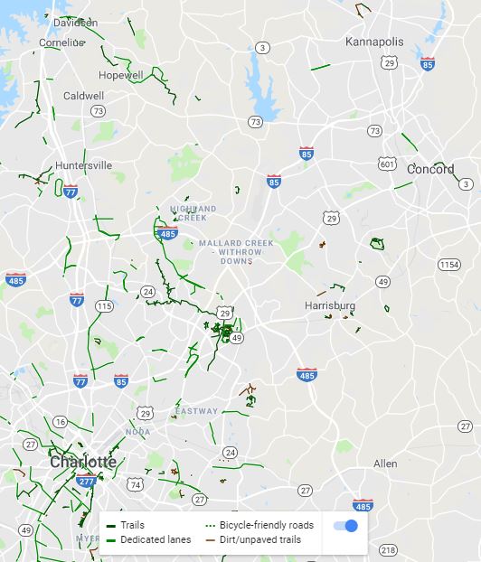
The rest of my journey to almost Mill Valley was much better than the beginning of my journey. I wrote “almost” because I actually did not make it all the way to the Mill Valley Fall Arts Festival. Since the festival closed at 5pm and I started my journey too late in the morning, I ended up turning around in Corte Madera. While the SMART Pathway does not reach Corte Madera, I biked along it from San Rafael to Larkspur. As the below photo shows, there are plans to extend the SMART Pathway and make it part of the 320-mile, world-class, multi-use rail-to-trail Great Redwood Trail. Yes, Kathy Fitzpatrick, this trail effort appears to be similar to the Columbia River Gorge’s Towns to Trails effort, which I wrote about in this 2021 post.

Future Blog Post

The Great Redwood Trail, which includes the SMART Pathway, is not the only regional trail planning effort in the Bay Area and Northern California. The planned 550-mile (400 miles are already complete) Bay Area Ridge Trail covers some of the route used for the Great Redwood Trail. The Bay Trail is a planned 500-mile walking and cycling path around the entire San Francisco Bay, running through all nine Bay Area counties, 47 cities, and safely across seven toll bridges. Stephan, we should take a future canoe or kayak trip on the San Francisco Bay Water Trail. I still want to explore Minnesota’s Boundary Waters Canoe Area Wilderness with you!

Last and in this case least impressive, Sonoma County Regional Parks created the North Coast Access Trails. I wanted to share this trail system because I want to bike from Petaluma to and along the Pacific Ocean. Unfortunately, this trail system is short and not well connected. Despite this less impressive regional trail system, I am excited to experience and write more about all of these efforts in future posts! Since I want to make my blog interesting to read, is there anything in particular that you want to read about?

Kannapolis is Changing at Eye Level

“Kannapolis is Changing at Eye Level” is a reference to “The City at Eye Level”. As you may know, I was raised in Kannapolis, NC. I lived in Kannapolis from when I was born in 1990 to when I moved to Charlotte in 2009 to attend UNC Charlotte. I also lived in Kannapolis from 2013-14 between graduating from UNC Charlotte and starting my Transportation Planning Internship at Toole Design Group in the Washington, DC region. While I did not plan to visit Kannapolis in 2020, the coronavirus forced me to work remotely and only fly within the US. Since spas inside resorts were closed due to the coronavirus, I decided to visit Kannapolis during my 24-day workation.

As the below 2020 photo (right) shows, the reconstruction of West Avenue in Downtown Kannapolis was completed in time for me to check it out during my visit. While I wish Kannapolis planners had constructed back-in parking because it is safer for all road users than front-in parking, I am impressed with how Kannapolis planners revitalized the deteriorating West Avenue. Since I grew up in Kannapolis, I remember how West Avenue looked in the 2017 Google Street View, which is on the left in the below photos.

Before (2017) and after (2020) West Avenue in Kannapolis. Source: Google Street View (2017)

Many people are unfamiliar with what back-in parking is and the benefits of this parking for all road users. Due to this, I wanted to share how Charlotte, NC has been using back-in parking before I continue to share about the changes to West Avenue. For readers unfamiliar with where Kannapolis is located, Kannapolis is a suburb of Charlotte. While I realize the big city usually implements new things before the suburbs do, I was hopeful that Kannapolis would implement back-in parking when it redesigned West Avenue because Charlotte has been using back-in parking for several years.

Instructions for Back-In Parking in Charlotte, NC. Source: City of Charlotte, NC
Source: City of Charlotte, NC

Since my dad needs me to help him move things around the house before I fly from Charlotte to Minneapolis today, I am going to write the rest of this post later. I took about 50 photos of the West Avenue changes yesterday. I plan to share many of these photos when I have more time to finish this post. In case Kannapolis planners read my blog, I wanted to thank you for making the changes to West Avenue. While I wish back-in parking was constructed, I enjoyed most of the changes so great work on revitalizing Downtown Kannapolis!

Raising Awareness About Suburban and Rural Transportation Issues

As I approach my one-year work anniversary at Clackamas Community College in June and a year being back in Oregon, I have been reflecting on my new job and life in general. While I am excited to share that all three of my conference presentation proposals this year were accepted, all of the conferences are in Portland. As the below photo shows, I presented on a three-person panel (photo includes the moderator) on April 25 about Transit Connections in Suburban and Mixed Land Use Environments at the Oregon Active Transportation Summit in Portland.

Since I believe my session was one of the few sessions that discussed suburban or rural transportation issues, the audience thanked me for raising awareness about these issues. While it is helpful to learn about Portland’s issues and from Portland’s success stories, the audience agreed with me that we need to discuss suburban and rural issues and context-sensitive solutions more at conferences. We realize that conferences have limited space for sessions and most of the session proposals probably came from urban areas. Would moving conferences from Portland to a suburban or rural place at least every few years help change the dynamics of the conference enough to discuss suburban and rural issues more?

20190430_134332

Ray presented on a panel at the Oregon Active Transportation Summit about Transit Connections in Suburban and Mixed Land Use Environments. Left to right: Jeff Pazdalski, Executive Director, Westside Transportation Alliance; Ray Atkinson, Transportation Systems Analyst, Clackamas Community College; Erin Wardell, Principal Planner, Washington County; (Moderator) Stacy Revay, City of Beaverton


The second conference I am presenting at is the National Urbanism Next Conference in Portland. I was selected to present the below lightning talk (pecha kucha) on May 7 about the topic: How do we harness emerging technologies to reach desired outcomes?

The title of my presentation is Beyond Urban Areas: Providing Suburban and Rural Clackamas County with Reliable Transportation Options. Since the lightning talks organizer had to close the online RSVP form after over 200 people confirmed they are attending, I expect to present to a large audience. While I should have time after my presentation to talk with the audience about my presentation, the lightning talk format does not allow time for a question and answer period after each presentation nor at the end of all the presentations.

As the below list of lightning talk presenters shows, I am the only presenter representing a college or university. Do you think I will also be the only presenter that discusses suburban and rural transportation issues?

Ray Atkinson, Clackamas Community College
Chris Bonnarigo, bKl Architecture
Regina Clewlow, Populus
Paul Curtis, Vectos South Ltd.
Maya Krolikowski, Crandall Arambula
Stephanie Lonsdale, Portland Bureau of Transportation
Martin Schmidt, Graz Linien
Rick Stein, Urban Decision Group
Tiffany Swift, Walker Macy
Darby Watson, Parametrix


The third conference I am presenting at is the Association of Pedestrian and Bicycle Professionals (APBP) Conference in Portland. My four-person panel, which includes me and professionals from Chicago, Ottawa, and a suburb of Philadelphia, was selected to present on August 26 about The Multimodal Suburb: Transforming Communities Through Planning, Policy, Advocacy… and a Little Rule Breaking. I will add my presentation to this post after I create it.

How would discussions at conferences change if they were in suburban or rural areas?

While I enjoy visiting Portland, I am frustrated that all of the conferences are in Portland because I believe many Portlanders and urbanists, in general, have difficulty thinking outside their urban bubble. I was guilty of this when I lived in Portland during graduate school at PSU. Most of my volunteer advocacy/activist work from Fall 2014-Fall 2016 focused on Portland.

Even though I did my workshop project in Tigard, which is a suburb of Portland, I likely would not have thought about Tigard issues if my workshop team had not chosen to work in Tigard. I visited Tigard for the first time when my workshop team started our project. I had also never visited Oregon City before moving here for my current job. I realize some Portlanders leave Portland for more than just recreating in the Cascades or the Oregon Coast, but I believe my perspective is accurate for most Portlanders.

Since I am still a volunteer Portland advocate/activist, I know that Portland volunteers have limited bandwidth. As Jonathan Maus at BikePortland.org tweeted, Portland volunteers are already getting burned out by their Portland advocacy/activist work. Due to this, is it reasonable to ask them to help me with my suburban and rural advocacy/activist work?

While I realize that many suburban and rural residents hate having Portlanders influence how their areas are planned, car-centric suburban and rural thinking is negatively impacting the entire Portland region. Widening highways and building more parking lots are hurting the entire Portland region, so Portlanders should be involved with suburban and rural decisions.

Future Blog Post

Since my one-year work anniversary at Clackamas Community College is in June and I will have been back in Oregon for a year in June, I plan to write a post about how my one-year goals went and what my two-year goals are.

Deploying and Rebalancing Dockless Bikeshare and Scootershare to Suburban Areas

I have a love-hate relationship with urban areas. While I love the urban lifestyle, I hate how challenging it has been to expand transportation services to suburban areas. As I wrote in this 2019 post, most of the focus throughout the US to plan for dockless bikeshare and scootershare has been on the largest cities. Even if governments in the Portland region want to expand the focus to suburban areas, are companies willing to expand to suburban areas?

Portland, OR Case Study

East Portland is a suburban area that the Portland Bureau of Transportation (PBOT) acknowledged in its 2018 E-Scooter Findings Report has “historically been underserved by the transportation system”. Since I will be referring to East Portland throughout this case study, please review the below map to make sure you know where East Portland is. As the other below map shows, East Portland has above average numbers of low-income people and people of color.

As the below scooter pilot fee schedule shows, one tool PBOT used to entice companies to deploy and rebalance scooters in East Portland was charging companies less for scooters that were located in East Portland. Companies were charged more for scooters that were located in urban areas like Central City.

To align business practices with Portland’s equity goals, PBOT also required companies to deploy at least 100 scooters or 20 percent of their fleet (whichever is less) in East Portland and offer a low-income fare. Only one company, Bird, complied with the East Portland fleet deployment requirements. Both Lime and Skip deployed below 90 percent of the minimum required scooters on average throughout the pilot. Companies only enrolled 43 Portlanders in the low-income plan. Along with Portland staff observations, this suggests low company performance in aligning business practices with Portland equity goals.

Only one company, Bird, complied with the East Portland fleet deployment requirements.

Source: 2018 E-Scooter Findings Report

While only Bird complied with the East Portland fleet deployment requirements, 243 scooters (9.8 percent of the total fleet for all three companies) were deployed to East Portland. 44,155 trips originated in East Portland during the first pilot period. This demonstrates the demand for additional transportation options. Since East Portland has suburban land uses compared to urban land uses in Central City, I believe trips in East Portland averaged 1.6 miles compared to one mile in Central City because origins and destinations are further apart in East Portland.

Due to it being a pilot program, I am impressed that PBOT actually enforced the rules. Even though this article does not state why Skip has not applied for PBOT’s second pilot program, which starts on April 26, being fined during the first pilot program likely discouraged Skip.

Over the course of the pilot period, PBOT issued two penalties, both to Skip Transport, Inc. One cited failure to meet East Portland fleet deployment requirements, and the other cited failure to meet the citywide deployment requirements outlined in the administrative rule and permit. Penalties were calculated for each day the company was out of compliance after a specified deadline.

Source: 2018 E-Scooter Findings Report

Since only Bird complied with the East Portland fleet deployment requirements during the first pilot, this likely caused PBOT to reduce the requirements for the second pilot. According to this article, “A minimum of 15 percent of a company’s total scooter fleet must be deployed east of I-205 (that’s down from a 20 percent minimum last pilot).” PBOT is also using a new carrot approach during the second pilot to entice companies to deploy scooters in East Portland. Companies will be allowed to increase the number of scooters in their fleet by 35% if they meet or exceed 2-3 trips per scooter per day.

Will suburban cities use Portland’s approach?

I have been asking people that work for suburban cities whether they plan to use Portland’s approach to regulating bikeshare and scootershare companies. Even though I have expressed my concern about them waiting to create regulations, everyone has told me that they plan to wait until Portland launches their second scooter pilot to see whether they need to create regulations. Since I do not want to embarrass any of my contacts, I purposely did not share which suburban cities I have been meeting with about this topic.

As I mentioned in my last post, Milwaukie is planning to allow companies to deploy scooters in Milwaukie soon after Portland launches its second pilot scooter program. I do not have scooter data for Milwaukie and assume scooter riders will use similar infrastructure as cyclists, so I reviewed bike trip data to understand where scooter trips likely will occur. Without any regulations to force companies to deploy and rebalance their scooters in low ridership areas, I predict companies will deploy and rebalance scooters in higher ridership areas. This approach will allow companies to make the most money on their investment.

Since Clackamas Community College’s Harmony campus is located in unincorporated Clackamas County just outside the southeast edge of Milwaukie’s city limit, I am concerned that companies will not supply enough scooters to Harmony campus to make this a reliable transportation service. Milwaukie is working on annexing Harmony campus into the city so Harmony campus will be within the city limit soon. Even when this happens the above map shows that most scooter trips will be in Downtown Milwaukie, which is 3.5 miles west of Harmony campus.

I am focused on Harmony campus because scooters could be used to make the first- and last-mile connection between Harmony campus, Clackamas Middle College and Clackamas Town Center. Since the CCC Xpress Shuttle only goes in a clockwise loop from Harmony campus to Clackamas Town Center, people have asked me to find another transportation service to go from Clackamas Town Center to Harmony campus. The shuttle service is not always frequent and does not operate every day, so people also want a more reliable transportation service from Harmony campus to Clackamas Town Center.

Harmony Campus to Clackamas Town Center

Source: Created by Ray Atkinson using Google Maps

While dock-based scootershare and bikeshare systems are more expensive than dockless scootershare and bikeshare systems, I believe a dock-based system would provide Harmony campus with more reliable transportation service because suburban users would not have to worry about the bikes or scooters staying in urban areas. Since I doubt a dock-based system is a financially feasible option due to lack of public funds (assumes no grant funding), is it possible to entice companies to deploy and rebalance dockless bikes and scooters to Harmony campus without government regulations?

Living Car-Free in American Suburb

Yes, you read the title of this post correctly. I am currently living car-free in the American suburb of Oregon City, which is located at the southern edge of the Portland, OR region.

Portland Region Map

Oregon City is located at the southern edge of the Portland region. I live and work in southern Oregon City. Source: AARoads

I will admit that I did not envision living and working in a suburb similar to my childhood hometown of Kannapolis, NC when I moved from Kannapolis to Charlotte in August 2009 to start undergrad at UNC Charlotte. Since I hated feeling forced to drive an automobile for every trip in Kannapolis and loved the freedom of many transportation choices in Charlotte, I never imagined returning to a suburb after graduating from UNC Charlotte. As I hope this post shows you, returning to a suburb may have been the best decision for my career.

While I still prefer living in an urban area and miss living in Arlington, VA’s award-winning Rosslyn-Ballston Corridor, I feel I am making a much bigger difference working in the suburb of Oregon City than I could have made working in a big city. This is mostly because I am the only transportation planner at Clackamas Community College (CCC) and one of the few active transportation planners in Oregon City.

I worked or interned in Charlotte, Philadelphia, Portland (OR), and the DC region, so I am confident that if I worked in a large city I would be in a large transportation department with many staff working on active transportation planning issues. While I am not trying to devalue the work that planners do in big cities, especially since they have to work on more complex issues than I have in Oregon City, how much difference does EACH of these planners have in creating change in their big city?

Since I am an entry-level transportation planner, I keep thinking about how much more difference I am making in Oregon City than I could have made as an entry-level transportation planner among many entry-level transportation planners in a big city. While I have to get permission to do things like apply for grants, I have been given plenty of professional freedom so far to pursue what I feel would be useful for improving multimodal transportation choices at CCC. This also means that I have to be more responsible for the decisions I make because I am the only transportation planner. Since I was micromanaged at a previous job (purposely not giving specifics because I do not want to embarrass a previous employer) and this overwhelmed my supervisor and me, I am thankful my current supervisor is not micromanaging me.

While I wrote earlier how Oregon City is a similar suburb to my childhood hometown of Kannapolis, Oregon City has much better active transportation access to Portland than Kannapolis has to Charlotte. After biking from my home in southern Oregon City to Downtown Oregon City on almost completely connected bike lanes, signed bike routes and sharrows, I can ride on almost completely connected trails all the way to Downtown Portland. The regional version of the below trails map can be found here. I actually helped create this map during my internship at Oregon Metro.

Portland to Oregon City Trails Map

Regional trails between Oregon City and Downtown Portland. Source: Oregon Metro

The below map shows most of the bike infrastructure between Oregon City and Downtown Portland. Since Portland’s famous neighborhood greenways and Oregon City’s signed bike routes and sharrows aren’t shown at this zoom level, I wanted to note that this is missing from the below map.

Portland to Oregon City Bike Map

Bike infrastructure between Oregon City and Downtown Portland. Source: Google Maps

Unless I rarely wanted to visit Charlotte or spend lots of time and money on transferring between multiple transit systems in the Charlotte region (I can take unlimited trips on TriMet’s light rail lines and buses throughout the Portland region for $5/day), I could not have lived car-free in Kannapolis. While the Carolina Thread Trail is working to connect trails throughout the Charlotte region and I volunteered to help create the Carolina Thread Trail Map, it is not possible today to use trails or any other bike infrastructure to bike between Downtown Kannapolis and Uptown Charlotte. Since Charlotte’s bike lanes, signed bike routes and sharrows are not shown at this zoom level, I wanted to note that this is missing from the below map.

Charlotte to Kannapolis Bike Map

Bike infrastructure between Uptown Charlotte and Downtown Kannapolis. Source: Google Maps

Oregon City has good biking and transit access to Portland, so I have been able to visit Portland frequently without driving. While some people in Oregon City have suggested I should buy a car so I can travel quicker, owning and maintaining a car is expensive. Plus, my job literally involves helping people to reduce car dependency. I can currently motivate people to reduce car dependency by telling them that it is possible to live car-free in a suburb like Oregon City because I live car-free here. How would they react if I told them I gave up and purchased a car for the first time in my life?

While I live car-free in my personal life, I cannot reach all my work trips by walking, biking and riding transit. Since I did not want to buy a car for work trips, my supervisor helped me reserve the below hybrid electric car, which CCC owns. This car is only available during the summer term because students learn how to reconstruct the car during other terms. Due to this, I have had to use expensive transportation network companies like Uber and Lyft to travel for work trips during the rest of the year. Even though I was nervous about whether my supervisor would support my car-free lifestyle, he has been very supportive.

I have so far driven the hybrid electric car to and from the Clackamas County Coordinating Committee (C4) Meeting near Mt Hood. Since this was the first time I drove after moving back to Oregon and I didn’t drive much when I lived in Virginia, I had to adjust to driving again. I have always been a slow driver, but Oregon drivers have been proven to be among the nation’s slowest drivers so I fit in.

2018-06-13 08.57.34

Hybrid electric car provided for work trips. Photo: Ray Atkinson

As my below Instagram post shows, the C4 Meeting provided me with good insights into Clackamas County’s transportation priorities. Unfortunately for my work to reduce car dependency, widening I-205 is definitely the top priority. Oregon DOT (ODOT), which presented about the I-205 toll and widening project during the C4 Meeting, has been trying to get support for widening I-205 by saying this will reduce traffic congestion. While traffic congestion may be reduced in the short-term, induced demand has shown that widening highways never reduced traffic congestion in the long-term. This is why ODOT needs to use the I-205 toll revenue to fund active transportation projects, which have been proven to reduce traffic congestion on highways. If ODOT is looking for an existing program to review, I recommend the I-66 Commuter Choice Program because revenue from the I-66 toll in Northern Virginia is directly funding active transportation projects in Northern Virginia.

I have not decided what my next blog post will be about, but it will probably be something about what I am experiencing in Oregon. Thank you for reading my blog!

Moving Back to Oregon to Work at Clackamas Community College

I’m excited to share that after submitting 127 job applications over the past seven months I have accepted a written offer to become the Transportation Systems Analyst at Clackamas Community College (CCC) in Oregon City! A short position description is below. The position is grant funded from Oregon Metro through June 30, 2019. Oregon Metro is offering the grant again and CCC plans to reapply for it.

Develop and implement strategies to expand transportation options and remove transportation barriers.  Refine and operationalize strategies outlined in the Transportation Management Plan.  Develop and implement transportation survey tools.  Gather and analyze transportation metrics for use in developing new transportation strategies.  Act as liaison with local, regional, and state government partners; work cooperatively to create transportation plans and projects that reflect the needs of the College.

Since CCC wants me to start working in June, I’ll be resigning from my full-time, temporary Urban Planner I position at the City of Alexandria, VA on May 18. I plan to move back to the Portland region soon after Memorial Day, which is in time to participate in Pedalpalooza. I’ll miss my East Coast family and friends. Thankfully, I’ll be able to catch up with many of them during my upcoming trips to Boston, Charlotte area, Erie, and Cleveland area. Since I was in grad school when I previously lived in Oregon from 2014-16, I’m looking forward to having more free time to explore the West Coast.

You may be wondering why I chose the below photo for the featured photo. Since CCC’s three campuses are located in three Portland suburbs and my new supervisor said no one has organized a group bike ride at CCC, my future job at CCC reminds me of when I co-founded and led the Cyclists Club at UNC Charlotte (UNCC). Even though I wasn’t hired by UNCC to work on transportation issues, I felt I was the de facto bike coordinator because this position didn’t exist. I’m excited to use what I learned working on transportation issues at UNCC to improve CCC.

66979_512634752108352_495543389_n

Ray organized and led slow Cyclists Club ride at UNC Charlotte on February 14, 2013

Since I took an Internet GIS course at UNCC during Spring 2013 and created the below interactive bike resource map with my teammate during this course, I’m planning to see whether CCC wants me to create a similar interactive map for CCC. While I’m impressed CCC’s transportation page includes walking, biking, transit, and carpooling, I’m looking forward to working with staff to improve it.

UNC Charlotte Bicycle Resource Page

Ray and Jacob created the UNC Charlotte Bicycle Resource Map in Spring 2013

You may have noticed that I focused on my UNCC experience before my Portland State University (PSU) experience. I did this on purpose because transportation planning and overall transportation behavior at PSU is so far ahead of CCC. PSU is a Platinum-Level Bicycle Friendly University, which is the highest level that has been awarded. While I offered during my interview that I could help CCC apply to become a Bicycle Friendly University, which is also open to colleges, CCC currently isn’t a Bicycle Friendly University. UNCC also wasn’t a Bicycle Friendly University until it applied for the first time in 2017 and was awarded the Bronze Level, which is the lowest level, so UNCC and CCC share many things in common.

Even though I want my ideas for CCC to be context sensitive, this doesn’t mean I can’t think about what I did at PSU. As this BikePortland post and the below photos show, Gerald and I organized a successful Bike PSU outreach event at PSU during Fall 2015. We organize this outreach event to start creating bike trains. Since we had difficulty finding a method to connect bike train participants while preserving their privacy and finding participants with similar class schedules that lived nearby each other, we weren’t able to start a bike train at PSU. I expect to have similar challenges organizing bike trains at CCC, but one big difference is I’ll be a permanent employee at CCC. I had to stop organizing bike trains at PSU when I graduated in June 2016.

bike-psu-cofounders

Ray and Gerald organized Bike PSU’s outreach event during Fall 2015 (Photo: Michael Andersen/BikePortland)

psu-bike-pins

PSU student participating in Bike PSU’s outreach event during Fall 2015 (Photo: Michael Andersen/BikePortland)

Yes, I realize I have focused mostly on biking and my new job involves working on more than just biking. As my previous post shows, I have multimodal transportation experience. My PSU team did our planning workshop project on walkability in Tigard, which is a suburb of Portland.

Since I’ve never been to CCC or Oregon City, I’m excited to explore a new area of the Portland region. Due to Oregon City being the first permanent Euro-American settlement in the Willamette Valley, first incorporated city west of the Rocky Mountains, and Oregon’s first capital (Oregon City was selected the capital before the creation of the Oregon Territory in 1848), Oregon City isn’t really new. I’m excited to learn more Oregon history by visiting the Museum of the Oregon Territory, which overlooks Willamette Falls in Oregon City.

Walkable Retirement Complexes Surrounded By Automobile-Dependent Land Uses

I have been on countless family vacations but my family’s most recent vacation was very unique for one major reason: transportation. From Saturday, December 24 to Friday, December 30, I was a van passenger and stayed with my family in hotels that are located in automobile-dependent areas adjacent to I-495 in Alexandria, VA (suburb of DC), adjacent to I-90 in Erie, PA, and adjacent to I-480 in North Olmsted, OH (suburb of Cleveland). Since my dad values easy interstate access, we have stayed in automobile-dependent areas during most family vacations throughout my life.

As soon as I had the freedom to choose where I wanted to stay, I escaped the suburbs and stayed at an Airbnb in a more walkable and transit-accessible location in Cleveland’s Gordon Square Arts District. I walked and rode transit everywhere until flying back to DC on Sunday, January 1. The below tweet shows the reaction I received from locals after they asked me what I was doing in Cleveland. Since this blog post was getting long, I moved the “Cleveland at Eye Level” section to my next blog post.

Visiting Grandmothers

Since I’m aware that this blog post could be seen as me complaining about not having freedom to explore outside of my family’s van, I want to clarify that my dad mostly chose to stay in automobile-dependent areas because we were visiting my grandmothers in automobile-dependent areas of Erie, PA and Westlake, OH. The retirement complexes where my grandmothers live are walkable only within the confines of their retirement complexes. Both retirement complexes are surrounded by automobile-dependent land uses so my grandmothers can’t safely walk beyond their retirement complexes. As an active transportation planner, this was very depressing to see.

Thankfully, catching up with both of my grandmothers wasn’t depressing. I enjoyed seeing how networked my Erie grandmother is into her retirement community. After eleven years at her retirement community, she literally knows everyone by name and everyone stops to talk with her. I loved seeing and hearing this! I also enjoyed chair yoga with her and my twin sister.

Since my Ohio grandmother just moved into her retirement complex the day before we arrived, she isn’t networked into her retirement community yet. However, I enjoyed seeing and hearing her take the initiative to meet people in her retirement community. I also enjoyed playing Kings in the Corner with her and my family.

Part 2 of 3 about my family trip can be read in my next blog post.