Ray Atkinson started this blog in 2014 when he moved from his childhood home in Kannapolis, NC (Walk Score of 0) to get his Master of Urban and Regional Planning degree from Portland State University (Walk Score of 100). He has never owned a car despite living in Memphis, TN. His email is gismap1@gmail.com https://www.linkedin.com/in/rayplans
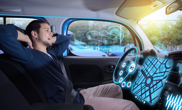
I have been asking myself about how self-driving cars could impact my car-free lifestyle. I wanted to write this post to document this thought. I am curious to see whether I will look back at this post someday and be amazed by actually owning a fully self-driving car. Since I currently avoid buying a car because I do not want to drive, I feel the availability of fully self-driving cars could result in me feeling comfortable enough to buy a car. As you may know, fully self-driving cars do not exist yet.
While I do not want my future girlfriend to pressure me into buying a car, my previous dates have asked me what it would take for me to buy a car. I usually answer them by saying that I do not plan to buy a car, and I am not open to changing my car-free lifestyle. Since not having a car is viewed in American culture as being poor, which is frustrating when other cultures do not have this viewpoint, I clarify that I can afford to buy a car. I just choose a car-free lifestyle. Due to the potential of self-driving cars, I have been changing my answer to sharing that I may purchase a fully self-driving car when it is available to purchase. Do you want to buy a self-driving car?
Could this be a photo of Ray someday?
My friend, Parisa, and I nerded out about this video today. Parisa shared the video with me. Since she is from Iran, I have also enjoyed learning more about Persian culture from her. She has enjoyed learning more about American culture from me. She is a PhD student researching AI technology at a university in Memphis. I enjoy having friends who want to have nerdy conversations with me. While I realize that AI technology is not perfect, I want to at least give AI experiments a chance. What do you think it will take for American culture to support self-driving cars as a way to achieve Vision Zero?
Future Blog Post
I have been working on the Safe Streets and Roads for All (SS4A) Action Plan. Since the SS4A grant requires that I keep the media informed about my work, I am confident that I will have media interviews to share in the future.
I have been debating for a few weeks about how to approach my next post because I do not feel knowledgeable or comfortable enough yet to share about specific projects that I am working on. While my previous posts show that I used to share thoughts on projects with limited knowledge of the place, I feel that I need to take a different approach in Memphis because I want to build trust with my community partners before sharing about their projects. Yes, the City of Memphis may own the public right-of-way (ROW) for certain projects, but the City cannot build and maintain projects alone. As I keep asking my community partners when I meet them, “Does the community feel ownership of the project?”
Does the Community Feel Ownership of the Project?
While that question may not seem significant, I have seen projects fail in other cities when the community did not feel ownership to build and maintain the project. I want my community partners to feel ownership to take care of the project, especially after the project has been constructed. In order to achieve this meaningful behavior change and build community ownership of the projects, I believe the change needs to move at the speed of trust.
Yes, the trust-building process will likely be tough work. I believe it is critical to achieve meaningful change in the community. Since community partners have asked me for my big-picture ideas, I want to encourage them to read about my dream to create neighborhoods that have robust in-person networks. Due to how many neighborhoods have speeding issues, the robust in-person networks will likely only be achieved when Memphians slow down enough to talk with their neighbors. I am assuming that you interpreted “slow down enough” to mean drive slower. This is one aspect of slowing down. Many Americans have a busy schedule, so I am also referring to slowing down our lives enough to take a deep breath. When was the last time that you took a deep breath and actually relaxed?
I wanted to share the video below because it helped me to think more critically about the important role people and their neighbors have in creating and feeling a part of their community. Do you understand what Michael Stone means by deeper materialism and the shift from vertical to horizontal transcendence?
Thank you to Will Selman for making me aware of the video through his blog post. I wish Michael Stone was still alive.
Another big-picture idea is shown in the below tweet (what are tweets called on X?). As a general statement about US cities, I found it interesting that building cities for cars fails even cars! Due to how many Dutch cities have been designed to make driving more challenging than active transportation, are you as surprised as I am that people can reach more jobs faster by car in Dutch cities than in American cities?
One of the craziest findings in urban planning is that you can reach more jobs faster by car in Dutch cities than American cities — *and* walking, cycling, and transit are faster in Dutch cities.
Importance of Moving at the Speed of Trust to Create Meaningful Change
Thank you to Cara Houser for sharing the idea for my post through the title of her most recent email newsletter. I have been meeting with a variety of community partners during my first month as the Bikeway and Pedestrian Program Manager at the City of Memphis. Since this is my personal blog, I want to clarify that I am not sharing my City employee perspective. I realize that I still have to be careful about what I share on my personal blog even after clarifying that this is my personal blog. My 2021 post about engaging historically marginalized communities in Oregon shows an example of how I prioritized moving at the speed of trust in order to create change in a community. While it may take more time to develop enough trust with community partners to create quality engagement over simply counting a critical mass of how many people are engaged in a process, I have been working towards developing trust with community partners during my meetings with them over the past month.
In addition to developing trust with community partners, I have been developing trust with coworkers in City Hall and on group bike rides. Due to how there are often silos where departments only communicate with coworkers in their department, I wanted to spotlight how everyone shown in the below photo works in different departments. While I try not to discuss work too much during our post-work group rides, I believe our group rides are a great opportunity to prevent silos from forming in our work.
Biking with coworkers in Arkansas. Source: Ray Atkinson
Future Blog Post
I was originally planning to write about my experience volunteering on the Urban Bicycle Food Ministry’s weekly bike rides. Since I have not participated in the Wednesday evening or Saturday morning ride yet, I will need to postpone blogging about this experience.
As I kept thinking about the distance needed to create a healthy work-life balance, I realized that being further from work may not matter if the neighborhood where I live provides a robust social network when I am not at work. Since social network in 2023 usually means an online network, I need to clarify that I am referring to an in-person social network. I have also learned through chatting with friends that my thought evaluation process for determining a robust in-person social network may not be obvious to lay people. While I plan to share research studies to try to support my evaluation process, I am trying a new approach to share my thought process. I welcome your feedback.
Donald Appleyard’s 1969 Livable Streets Research
I think the below Streetfilms video, which is in Matt Turner’s blog post, about Donald Appleyard’s 1969 Livable Streets research in San Francisco should help readers understand my evaluation process for determining a robust in-person social network. Readers can learn even more by reading Donald Appleyard’s 1981 book titled Livable Streets. His son, Bruce, published Livable Streets 2.0 in 2020. I find it depressing that livable street issues still exist in 2023. Do motorists even realize (they may need to start by even thinking about the problem) how they are impacting in-person social networks when they are driving on neighborhood streets?
A few friends have asked me what I find “depressing” in the previous paragraph. Due to how American society usually does not openly discuss mental health issues like physical health issues and people with mental health issues do not always feel comfortable discussing their issues, I am thankful to have family and friends who are comfortable enough with me to ask about my mental health issues. Regarding what I find depressing about livable street issues still existing in 2023, I am depressed that not much has been done to resolve the known issues. While these issues are known to many planners, the issues may not be known to the general public. Since the general public likely is not aware of the issues, I believe planners like myself have the tough responsibility to educate them about the issues. I believe the needle will not be moved quickly to resolve the issues until the general public is aware that these issues exist.
I am hopeful that finding a neighborhood with a robust in-person social network will also help improve my mental health issues, which includes creating a healthier work-life balance. While some people may believe that a healthy work-life balance is created by just being in a living space when not at work, I believe being home is more than just a living space. As I will discuss further during the topic on “home territory”, access to people near my living space also contributes to creating a healthy work-life balance. Since I find it challenging to stop thinking about planning issues when not at work, I am hopeful that living in a neighborhood that has a vibrant in-person social network will help me to stop thinking about planning issues when not at work. I realize my vision of the perfect neighborhood does not exist. I can at least try to find a better neighborhood to live in.
In case readers do not watch the video, I want readers to focus on the below figure from Donald Appleyard’s 1969 research in San Francisco because it shows how light, moderate, and heavy traffic impact in-person social networks along one block on each street. The below quotes show the quotes that meant the most to me. What quotes mean the most to you? Do you relate to any of the quotes?
I feel it’s home. There are warm people on this street. I don’t feel alone.
Resident on street with light traffic
It’s not a friendly street — no one offers to help.
Resident on street with heavy traffic
Source: Donald Appleyard’s 1969 diagram of intra-street social connections. Lines represent specific social connections and dots identify where people were reported to gather.
While I am not sure why the below figure is not black and white like the other figures, the figure was still created by Donald Appleyard. I found the figure in Jason Kottke’s blog post. According to Donald Appleyard in his 1981 book, the home territory is defined as the “area over which you feel you have a sense of personal responsibility or stewardship”. Do you see how none of the home territories drawn by residents on the heavy traffic street actually crosses the street? Now let’s compare this with the home territories drawn by residents on the light traffic street. It’s awesome to see how many home territories on the light traffic street actually cross the street!
Source: Donald Appleyard
2011 Livable Streets Research
Research conducted in 2011 on three Bristol streets found similar results. As someone who is depressed when my neighbors just go from their cars to their homes without talking with me, I can relate to the below quote. Surprisingly, I do not live on a street with heavy traffic. Due to Bristol being more walkable than Petaluma, walkability may matter more in this context than how much traffic exists on the street.
people just go from their cars to their houses
Resident on street with heavy traffic
Source: Hart, J. and Parkhurst, G. (2011) Community interaction on three Bristol streets.
The Bristol study also researched each resident’s perspective on their “home territory”. The below figure shows very similar results to what Donald Appleyard found in his San Francisco study. Do you notice how residents living on the street with light traffic drew larger home territories than the residents living on the street with heavy traffic? Do you also notice that many of the home territories drawn by residents living on the street with light traffic actually cross the street? On the other hand, do you see how only one of the home territories drawn by residents living on the street with heavy traffic actually crosses the street?
“During the interviews, residents were asked to draw their ‘home territories’. Home territory was defined as the “area over which you feel you have a sense of personal responsibility or stewardship” (Appleyard, 1981). The results confirmed Appleyard’s findings about the relationship between traffic level and the range of home territories.”
I am adding Hayden Clarkin’s tweet about this 2021 German study because it relates to the above “home territory” drawing results or mind mapping. I believe the home territories were drawn by adults, so I am more heartbroken by seeing children that are negatively impacted by cars. I know many of my readers have children. What do you think your children would draw about their trip to school? Do you drive your children to school, or do they have the freedom to walk or bike to school? If you drive them to school, did you consider providing them with the freedom to walk or bike to school?
When asked to draw their trip to school, children who walk to school drew a more vibrant picture than those driven in a car. Every student should have the option to walk or bike to school in a safe manner, full stop. (via Margrit Stamm) pic.twitter.com/dlKEtrTRYJ
Before I discuss applying the research, I am aware that Petaluma is not San Francisco or Bristol. The land use context is important when applying real-world research. Due to Petaluma’s suburban land use, results from San Francisco’s urban land use may be too different to apply the research when reviewing suburban neighborhoods. One way that the land use difference could be resolved is by comparing the vehicles per day or per peak hour on each street. I plan to write more about this topic, so I could do this comparison in a future blog post.
With the above land use caveat and the understanding that my blog is not going through an academic peer-review process, I have not experienced any Petaluma neighborhoods that have a robust in-person social network. While I may not have enough time to research this further before my roommate finds someone to replace me on the lease, I am hopeful that I will find a Petaluma neighborhood with a robust in-person social network before deciding where to buy my first home within the next year or so. I try to look for silver linings, so I wanted to share the photo below that I took today in Downtown Petaluma. Despite the rain (yes, California has a wet season like Oregon), I enjoyed talking with this artist as she painted a downtown scene. This experience gave me hope that Petaluma has some in-person social networks.
Source: Ray Atkinson
In case livable street researchers read my blog, I want to challenge you to do further research using Donald Appleyard’s research by studying how in-person social networks change before and after a street has automobile traffic completely removed. This tweet helped me think of this challenge. Are you willing to accept the challenge?
Less through-traffic in a streets means: ⬆👫 more social interaction ⬆👩👩👧👧 more friends ⬆🏖 more places to gather. ⬆🏠 larger home territory (Appleyard, 1981)
I could not figure out a way to fit this 2019 Cairo research study into the above discussions of other research studies because the Cairo research did not compare automobile congestion on different streets. However, I wanted to share the Cairo results because robust in-person social networks along street blocks were studied. Even with many cars parked along the streets, I am impressed by the level of in-person social interactions. The map key shows how these interactions vary on Friday from 3-5pm and 8-10pm. What do you notice from the research results?
Behavior mapping of staying activities on the sidewalk segments of Ibrahim Street in Cairo
Future Blog Post
Since I desperately want to live in a home again that feels comfortable, I hope my next post will be about my new living situation. I wish I did not have to wait for my roommate to find someone she wants to live with before I can be removed from the lease. As I have done with previous moves, I plan to write about my commute. I may decide to stay in the same apartment complex, so I may not have a new commute. Either way, I plan to discuss further about whether my neighborhood and any other neighborhood in Petaluma has a robust in-person social network. While I am struggling to learn Spanish using Duolingo, I realize that I may need to improve my Spanish skills in order to join certain in-person social networks in Petaluma and elsewhere in California.
Oregon’s Stop As Yield for cyclists law (aka Idaho Stop Law) goes into effect this Wednesday, January 1. Since many people, including cyclists, appear to be confused about what Oregon Senate Bill 998 changes, I recommend this Bike Law post and please watch this video.
Even though the new law has safety benefits, most comments I have read on mainstream Oregon news have been from frustrated motorists. Many of these motorists shared how they believe that cyclists already do not follow the laws. Despite the safety benefits from Idaho’s use of the Stop As Yield Law, many of these motorists shared how they supported the Oregon SB 998 because they believe it will kill cyclists for rolling through intersections. While I try to always follow the laws, I frequently do a rolling stop when biking because coming to a complete stop at every stop sign would be exhausting.
I actually had a motorist yell and argue with me when I accidentally did a rolling stop while biking through a stop sign on the Trolley Trail north of the Clackamas River in Gladstone, Oregon. Even though mainstream Oregon news is helping to educate everyone about what the new law allows and prohibits, I expect many motorists to harass me about legally doing a rolling stop while biking.
While I took the below photo about another bike issue in Virginia, I am curious whether a similar sign could reduce how many motorists harass me about legally doing a rolling stop. I could put “Bike (symbol) Rolling Stop Is Legal SB 998”. What do you think?
As someone who studied transportation planning and engineering abroad in the Netherlands, I feel the need to share that stop signs are rare in the Netherlands. Yielding (shown with shark’s teeth painted on and built into the street) is the default on streets where there would be stop signs in the US. Since the Netherlands tries to avoid sign clutter, yield signs are often not used with the shark’s teeth. The US has too much sign clutter, so I wish the US would also try to reduce sign clutter.
While my focus through May will be on studying for the American Institute of Certified Planners (AICP) Exam, I may take a break to write a follow-up post about how biking changed for me after SB 998 goes into effect on January 1. Hopefully, motorists will harass me less when I legally do a rolling stop while biking and I will not need to create a sign for my bike to educate motorists about SB 998.
Since I am the Transportation Advisory Committee’s representative on the Downtown Oregon City Transportation Demand Management (TDM) Implementation Working Group, the City of Oregon City invited me to join this group on a tour of the Willamette Falls Legacy Project and Downtown Oregon City. In case you are unfamiliar with the Willamette Falls Legacy Project, I recommend watching the below video.
Even though the working group knows we need to prioritize people over cars because there will not be enough space to park all the cars on the Willamette Falls Legacy Project site, I found it interesting that the first thing the tour guide showed us was where cars would be parked on the future site. The tour guide even shared a specific location for the interim on-site surface parking lot and an estimate on the number of cars that could be parked in this lot.
While I assumed the tour guide was referring to parked cars because most people in Oregon City drive, he only said “parking” so I asked the tour guide to clarify what type of parking and whether there would be parking for bikes. My assumption was correct that he was only referring to car parking when he said “parking”. Thankfully, he said there would also be parking for bikes because the City requires bike parking. However, he was unable to provide a specific location for bike parking and how many bikes could be parked.
According to the below diagram, car “parking supply at full build-out of the site is estimated at 1,150 spaces off-street, and 85 spaces on-street.” Even though the City requires bike parking, I could not find any diagram for bike parking. This shows me that the project vision prioritizes car parking. On a positive note, minimum car parking space requirements may be reduced by up to 50% because the site is part of the downtown parking district.
In addition to being excited to hear about the potential for a 50% reduction of car parking, I was excited to hear that City staff are considering whether to remove mandatory car parking minimums in the downtown parking district. While I am sure there will be internal and public resistance, City staff want to give developers the flexibility to decide whether or not to include car parking in their projects. City staff said the mandatory car parking minimums have prevented many downtown developments from being built because the projects could not pencil out. As the below map shows, there is an international movement to remove car parking minimums.
While I was not satisfied with the tour guide’s answers, I was told that we would discuss bike parking more at a later point in the planning process. Even though I am used to bike parking being an afterthought in Oregon City, I was still frustrated that I had to ask for “parking” to be clarified and request that bike parking be discussed. Do Dutch and Danish planners have to ask for this clarification or do their tour guides automatically specify which type of parking?
As you know, I will be presenting on a panel at the Association of Pedestrian and Bicycle Professionals (APBP) Conference in Portland on August 26 from 1:45-3:15pm (here is the agenda for August 26). Several Dutch and Danish planners that I have communicated with will be at this international conference, so I plan to ask them the above parking question.
Ray’s Behavior Change from 2009-2019
While I now get frustrated about having to clarify “parking” and request that bike parking be discussed, this shows how much I have changed over the past ten years. As I wrote about in this 2014 post and the below 2009 article shows, I used to advocate for cars by supporting the widening of North Carolina Highway 3 in Kannapolis. I said the below statement during my senior year at Northwest Cabarrus High School and just a semester before I started at UNC Charlotte. I was actually one of the few residents that supported the widening project. As this article shows, most people opposed the project because they wanted to maintain the rural character along this section of Highway 3. They felt widening Highway 3 would bring too much dense development and traffic congestion. Since I tell people that I was raised in a suburban area, it feels weird to see the articles described my home as being in a rural area.
Not everyone was opposed to the idea of a wider N.C. 3. Ray Atkinson lives about a mile off of the highway.
“I think it’s good to plan for growth,” Atkinson said. The N.C. Research Campus in Kannapolis would benefit from the proposed improvements, he added.
Kannapolis Citizen article from January 28, 2009
Translating My Kannapolis Experience to Oregon City
Even though most people on the Willamette Falls Legacy Project and Downtown Oregon City tour saw me as the bike advocate, I am curious how much their perception of and interaction with me would have changed if I shared my Kannapolis experience. In addition to advocating for cars in Kannapolis, I experienced the closure of Cannon Mills (aka Pillowtex) in 2003. I have followed the redevelopment of this closed mill site into the North Carolina Research Campus. The redevelopment has also included areas beyond the closed mill site in Downtown Kannapolis. This redevelopment had such a large impact on me that I studied it for my high school senior exit project in Fall 2008. The Willamette Falls Legacy Project and redevelopment of Downtown Oregon City reminds me of my work in Downtown Kannapolis.
Mrs. Andersen, who was my high school teacher and advisor for my senior exit project, and I looking at a 1950s map of Kannapolis, NC in Fall 2008.
Translating My Tigard Experience to Oregon City
I also see similarities between my work in Tigard and Oregon City. As this 2016 post shows, my PSU planning workshop team consulted for the City of Tigard and worked with State of Place to conduct a walkability study in the Tigard Triangle and Downtown Tigard. The Downtown Oregon City TDM Implementation Working Group plans to work with City staff to conduct a walkability and bikeability study in Downtown Oregon City. I plan to write a future blog post about this study after it launches.
Since I believe most of the focus throughout the US to plan for electric-assist dockless bikeshare and scootershare has been on the largest cities, I feel the need to push for more regional planning. My employer, which is Clackamas Community College (CCC), has three campuses that are located in three suburban cities within the Portland region. While I am still surprised to be living car-free and working in America’s suburbia, this experience has provided me with a unique perspective on why regional transportation planning is crucial.
As the below map shows, Portland received responses from throughout the region to its 2018 e-scooter pilot user survey. Even though Portland’s e-scooter pilot was legally limited to Portland, I saw e-scooters as far south as Oregon City. I am not sure whether the companies or their customers were fined for parking scooters outside of Portland. While CCC and jurisdictions within Clackamas County are nervous about allowing e-scooters and e-bikes, is it feasible to ban e-scooters and e-bikes in Clackamas County when people will likely keep riding them south from Portland?
Through serving on the City of Oregon City’s Transportation Advisory Committee and Clackamas County’s Pedestrian/Bikeway Advisory Committee and talking with residents, I have learned that many Clackamas County residents are resistant to Portland-style transportation thinking and do not want anything to be planned. They believe planning will bring change to their desired small town and country lifestyles, so they have asked me and government staff to stop all planning efforts. Even though I tell residents that e-bikeshare and e-scootershare could reduce traffic congestion and demand for auto parking, which are their concerns, they keep telling me that they only want to widen roads and build more auto parking so they can get places faster by driving. They do not believe me when I tell them that e-bikeshare and e-scootershare have been proven in other places to reduce auto trips and increase non-auto trips.
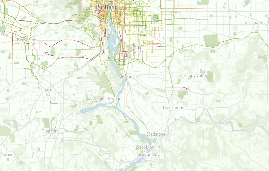
I realize the residents that want to drive likely will not use e-bikeshare and e-scootershare. However, it has been challenging to convince them that other residents like me want to use these shared mobility services. People who want to keep driving will benefit from this because they likely will see reduced traffic congestion and demand for auto parking. As the below map shows, few people currently bike in Clackamas County, which is located south of Portland. This is a major reason why it is hard to convince auto-dependent residents that enough people will use shared mobility services in Clackamas County. I would like to show a similar map for scooter trips, but Portland only released scooter data for trips in Portland.
I experienced a similar public backlash when my employer, which was MetroBike, was hired by Montgomery County, MD to expand Capital Bikeshare into suburban areas. Since Capital Bikeshare uses stations and bikes cannot be locked within being docked at a station, Montgomery County could have asked MetroBike to stop the expansion. While some dockless bikeshare and scootershare companies have tried to encourage their customers to park in designated areas, the bikes and scooters are not required to be parked in these areas. This is the main reason why I believe dockless bikeshare and scootershare are coming to Clackamas County whether or not the residents want it. Even if Clackamas County requires the companies to remove their bikes and scooters, bikes and scooters will likely keep coming to Clackamas County until Portland forces the companies to leave the region.
As a planner and someone who wants more transportation choices, I want to be prepared for bikeshare and scootershare. While the public may believe it is not possible to plan for this, I believe it is possible as long as my partners are willing to keep working with me to create and implement a plan. Even though bikeshare and scootershare are quickly evolving, I have found this resource to be useful in my planning effort.
I have only been back in Oregon for eight months, but I am excited to share that I have quickly become a leader in the planning process to prepare the Portland region for bikeshare and scootershare. Since I want to make sure the planning process includes an equity lens and integrates smoothly with other transit services, my partners include TriMet (Portland region’s transit), Metro (Portland region’s MPO), several non-profit equity community groups, and several cities and counties. While Portland has been working with Ride Report to analyze its data, my suburban partners have been evaluating whether and how to include private companies in our planning process.
Portland plans to award permits and launch E-Scooter Pilot 2.0 for a year early this spring and expand Biketown (bikeshare) to include e-bikes this fall when it renews its contract with Motivate, which is owned by Lyft. Since Uber owns JUMP, which provides the bikes for Biketown, it should be interesting to see how Uber and Lyft work together run Biketown. I have never seen two competing companies run the same business together!
I usually write posts mostly from my viewpoint because I want my blog to be mostly from my viewpoint. I am making a rare exception with this post because I am not a legal expert and my last post happened to be about Bend. While I read BikePortland almost daily and many of their posts fascinate me, I chose to make a rare exception to write about this post because Jonathan Maus thoroughly researched the legal issue and it raises questions about what I experienced in Bend.
Before I read Jonathan’s post, I thought it was common sense that a bike lane legally continues through the intersection. I am shocked by Deschutes County Circuit Court Judge Adler’s ruling.
Judge Adler ruled that he saw “no authority” to support the contention that bike lanes continue through intersections in Oregon.
While I have never had any personal legal issues while biking, do I need to start leaving the bike lane and using the travel lane when going through intersections in Oregon to prevent my legal rights from being lost? As comments below Jonathan’s post explain, I am not the only cyclist in Oregon asking this question.
I also found the below statement interesting. Even in bike-friendly Oregon, it is believed that people do not treat bike lanes like travel lanes. As someone who bikes daily in Oregon, I agree with this perspective. While neither type of lane physically (no paint) continues through the intersection, I have not seen anyone questioning whether the travel lane legally continues through the intersection. Why does the same not apply to the bike lane?
Prosecutor Andrew Steiner said many people today do not treat bike lanes like vehicle lanes, though they are.
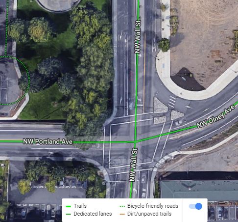
Since I am a geographer, I would normally have started this post with where the bike lane is located in Bend. I felt readers needed the legal and culture details to fully understand the bike lane legal issue, so I postponed sharing the bike lane location. While the below Google Maps screenshot shows green lines for where the bike lanes continue through the intersection at NW Wall St and NW Olney Ave, the white bike lane paint does not actually continue through this intersection. The white bike lane paint stops where the intersection begins and restarts where the intersection ends. The same is true for the travel lanes.
Location of the bike lane legal issue in Bend, OR. Source: Google Maps
Portland had a similar legal issue
Unfortunately, Bend is not the only Oregon city to have experienced this legal issue. Portland had a similar legal issue in 2009. As this BikePortland post discussed, Multnomah County Circuit Court Judge Pro Tem Michael Zusman found that the collision did not occur “in the marked area comprising the bicycle lane.”
You are probably as confused as me after reading this post. Since I do not want to change how I bike through intersections in Oregon, I hope I can trust what Jonathan wrote in his 2018 post.
Let’s be clear: Even though the legal definition of a bicycle lane (ORS 801.155) doesn’t specifically address intersections, the legal protection of a bicycle lane absolutely does continue through an intersection even if the markings do not.
Jonathan’s viewpoint is shared by former Portland Police Bureau Captain Bryan Parman.
“We all know that lanes continue through an intersection, we just don’t lay down a bunch of criss-crossing lines because it would be confusing.” He also said, “It’s a poor ruling in an individual case but it doesn’t change the way we do business.”
I’m following up on my last post, which discussed Capital Bikeshare and dockless bikeshare in the Washington, DC region. While I agree that dockless bikeshare companies should be held accountable to making sure their bikes are parked correctly, why aren’t dockless automobile companies being held to the same standard? Dockless automobiles have been parked illegally for decades. Where is the public outrage? Why is most of the public outrage focused on dockless bikes?