Ray Atkinson started this blog in 2014 when he moved from his childhood home in Kannapolis, NC (Walk Score of 0) to get his Master of Urban and Regional Planning degree from Portland State University (Walk Score of 100). He has never owned a car despite living in Memphis, TN. His email is gismap1@gmail.com https://www.linkedin.com/in/rayplans
I wanted to share a few more thoughts about Arcata before I depart tomorrow to hike and kayak with my retired friend, Stephen Walton, in Redwood National Park. As a reminder, I am still writing this post on my phone because I decided to leave my laptop at home. “Arcata at Eye Level: Part 2” is a reference to “The City at Eye Level”.
Importance of flipping stop signs on bike boulevard
I seeked out biking on Portland’s neighborhood greenways when I lived in Portland because I could avoid having to stop at every minor crossing. Unfortunately, Arcata did not design its bike boulevard (aka neighborhood greenway) the same way. While Arcata signed bike boulevard routes, I believe there were stop signs at every intersection. Flipping the stop signs at intersections with two stop signs or removing the stop signs on the bike boulevard at four-way stops is an easy and cheap way to prioritize people using the bike boulevard. As I have also been observing in Petaluma, it can be challenging to gain support from motorists for this idea because cyclists would be prioritized over motorists. Has your city flipped any stop signs to prioritize people over cars?
Arcata bike boulevard. Photo: Ray Atkinson
Car parking access using trail looks similar to approach used in Houten, Netherlands
I was so surprised by seeing car parking access provided using a trail in Arcata that I asked people walking by whether cars actually drive on the trail to access car parking. While the people walking did not understand what I was asking because they just said it’s a trail, I plan to ask the City of Arcata staff how this arrangement works. Since the intersection sign shows L Street and not a trail name, it appears that this section of L Street was converted to a trail. Due to this being a trail, I am also curious why the sign has “road” in it. A trail is not a road, so does the Manual on Uniform Traffic Control Devices (MUTCD) not have a sign that states “Trail Closed To Thru Car Traffic”?
“Road Closed To Thru Traffic” sign next to car parking on trail in Arcata. Photo: Ray AtkinsonCar parking that can only be accessed from the trail in Arcata. Photo: Ray Atkinson
The photo below is from when I biked in Houten, Netherlands. The car parking connection to the trail looks very similar to the approach used in Arcata. While I am not sure whether people in Houten actually drive on the trail, do you see how the car parking is connected to the trail?
Trail connected to car parking in Houten, Netherlands. Photo: Ray Atkinson
Future Blog Post
My vacation continues tomorrow in an area of northwest California that I have not explored yet. My friend and I plan to hike and kayak in Redwood National Park through Friday. Since one of my vacation goals is to be off the grid as much as possible, I am looking forward to having limited or no internet and cell services through Friday. While Arcata put the bar high in weird and surprising approaches to transportation planning, I hope to see more weird transportation planning approaches that surprise me. Am I surprised too easily, or are you also surprised by what I found?
Tomorrow, September 19, is my birthday. September 19 also happens to be the start of Disability Rights Washington’s Week Without Driving. While Ian Davidson is in Oregon, it appears Week Without Driving is only organized in Washington. World Car Free Day also happens to be this week on September 22. As someone who lives a car-free lifestyle, these challenges feel weird to me. However, I hope they convince other people to temporarily experience car-free living. Will you be participating in Week Without Driving or World Car Free Day?
This week, I am participating in #WeekWithoutDriving to better understand the barriers non-drivers (for example people with disabilities, young people, seniors and people who can’t afford cars or gas) experience in accessing our community. https://t.co/TYfWhLGgS5 1/x #orpol
Ray’s Birthday Wish Is To Feel Safe and Comfortable When Biking, Walking, Hiking, and Riding Transit
As I was biking, walking, and riding the Sonoma-Marin Area Rail Transit (SMART) train from Petaluma yesterday to attend the Mill Valley Fall Arts Festival, I was thinking about my birthday wish. While birthday wishes are probably supposed to be cheap like when I was excited to get a bike as a child, I now desperately want to see the world be improved by creating expensive 8-80 Cities. I should clarify that constructing these 8-80 places will be costly, but humans are already planning to construct expensive places. Behavior change to human-scale transportation planning will be key to successfully constructing 8-80 places.
Since my post includes suburban and rural areas, I wish 8-80 Cities included suburban and rural areas. I believe they are focused on large urban areas. Yes, I realize the 8-80 Cities non-profit organization has limited bandwidth. I am thankful that this organization exists at all to help places with their transformations. While 8-80 Cities may not be involved in the following efforts, I got excited and hopeful as I researched more about all of the regional efforts to create safe and comfortable routes to bike, walk, hike, and ride transit in the Bay Area and Northern California. Since you may not understand the significance of these efforts if you have not experienced the unsafe and uncomfortable existing routes, I want to show you one of these routes that I took yesterday.
Even though I am sharing the below experience from my perspective, 8-80 Cities is focused on making places usable by people from 8 to 80 years old. Due to this, please think about whether an 8-year-old or 80-year-old would feel safe and comfortable biking the route. I have noticed that many experienced adult cyclists say “I” statements when discussing whether a route is safe and comfortable. Yes, the route feels safe and comfortable to an experienced adult cyclist. I want to encourage these cyclists to think about the route from the indicator species’ perspective, which is discussed in the below video. Even better, I would love for these cyclists to invite an 8-year-old or an 80-year-old to ride along the route with them. How much do you want to bet that they will not feel safe and comfortable enough to even accept the ride-along invite?
Biking From Petaluma To SMART’s Novato San Marin Station
The below section of Petaluma Blvd S made me feel so uncomfortable that I ended up getting off my bike and walking. Yes, I have an extreme fear of heights but I may have been able to stay on my bike if there was a trail here. Due to how uncomfortable biking next to automobiles is, I prefer to stay closer to the grass when biking. As the below photo shows, the bike lane was narrowed to provide space for the guardrail and concrete barrier. I decided to cross the road and walk my bike against traffic next to the grass.
I was surprised by how many road cyclists wearing lycra and having no rack for panniers were riding the same route. They kept passing me because I prefer to ride slowly on a hybrid bike that has a rack and panniers. Since they had no bike lock and were only carrying a water bottle, I do not understand their approach to bike touring. I guess they were just biking fast and not planning to lock their bike somewhere to stop for a meal. While I frequently see this approach to biking, it is hard for me to imagine not carrying a lock and planning where to stop for a meal. As I walked my bike down the steep hill (yes, it’s not a very steep hill), two road cyclists asked if I was doing okay. At least they were friendly even when they were biking fast!
Source: Google Maps
I felt much more comfortable at the bottom of the hill when I saw the bike trail, which is the green line south of Mickelson Pumpkin Patch to cross Highway 101. As you compare the zoomed-in map to the overview map, pay attention to the green line south of Mickelson Pumpkin Patch. Since Fire Road is a dead-end road, I would have had to bike back to Petaluma to use a different route to continue south. I Street, which goes by Tara Firma Farms, is a much hillier route than biking on Petaluma Blvd S. The 14.5 miles goes to SMART’s Novato San Marin Station. Since I was out of shape, I took a break from biking and rode the SMART train to the San Rafael Station.
Source: Google Maps
Source: Google Maps
Disappointing Park(ing) Day Weekend in San Rafael
Due to this weekend being Park(ing) Day weekend, I was hoping to see a Park(ing) Day event in Downtown San Rafael’s unused parking spaces. According to the Park(ing) Day website, Hope Housing Of Marin previously participated in Park(ing) Day. It appears there is no Park(ing) Day event in San Rafael this weekend.
Yes, I was excited to see parklets! I just wish there was more bike parking. The only nearby bike rack, which is on the sidewalk, is hidden and blocked by the clothing display. Should I have moved the clothing display and used the bike rack?
The rest of my journey to almost Mill Valley was much better than the beginning of my journey. I wrote “almost” because I actually did not make it all the way to the Mill Valley Fall Arts Festival. Since the festival closed at 5pm and I started my journey too late in the morning, I ended up turning around in Corte Madera. While the SMART Pathway does not reach Corte Madera, I biked along it from San Rafael to Larkspur. As the below photo shows, there are plans to extend the SMART Pathway and make it part of the 320-mile, world-class, multi-use rail-to-trail Great Redwood Trail. Yes, Kathy Fitzpatrick, this trail effort appears to be similar to the Columbia River Gorge’s Towns to Trails effort, which I wrote about in this 2021 post.
The Great Redwood Trail, which includes the SMART Pathway, is not the only regional trail planning effort in the Bay Area and Northern California. The planned 550-mile (400 miles are already complete) Bay Area Ridge Trail covers some of the route used for the Great Redwood Trail. The Bay Trail is a planned 500-mile walking and cycling path around the entire San Francisco Bay, running through all nine Bay Area counties, 47 cities, and safely across seven toll bridges. Stephan, we should take a future canoe or kayak trip on the San Francisco Bay Water Trail. I still want to explore Minnesota’s Boundary Waters Canoe Area Wilderness with you!
Last and in this case least impressive, Sonoma County Regional Parks created the North Coast Access Trails. I wanted to share this trail system because I want to bike from Petaluma to and along the Pacific Ocean. Unfortunately, this trail system is short and not well connected. Despite this less impressive regional trail system, I am excited to experience and write more about all of these efforts in future posts! Since I want to make my blog interesting to read, is there anything in particular that you want to read about?
My Tucson vacation has ended. I miss wearing shorts and seeing constant sunshine. While I accomplished the main activities that attracted me to vacation in Tucson, I did not feel comfortable biking to additional activities that I tried to plan after arriving in Tucson. Yes, I could have rented a car or used Uber or Lyft to access these additional activities. I have not driven a car for several years because driving is too stressful for me. I may have been too frugal but I wanted to avoid spending money to use Uber or Lyft. Since I am passionate about making the additional activities comfortable in the future, I want to share what happened.
Please improve The Loop!
The main reason why I wanted to vacation in Tucson was to bike along 131-mile The Loop. The trail is 131 miles as expected, but I quickly lost interest to bike much of it. As someone who is used to seeing water flowing in rivers, I was surprised to see dry rivers when biking along The Loop. Yes, this was my first time outside the airport in Arizona. Several people who grew up in the Southwest told me that dry rivers are common throughout the Southwest. They also taught me about washes, which I saw throughout Tucson and in the eastern Saguaro National Park. While there is no trash shown in the below photo, I was disgusted to see trash in many locations along the dry rivers.
I was also looking forward to chatting with people as we biked along The Loop. Unfortunately, all of the people I saw biking were fast cyclists that quickly passed me as I slowly biked. No one slowed down to talk with me! I talked with a few people in the parks that are located along the trail, but most of the people were too busy to talk for a long time. Due to how boring and depressing biking along the dry rivers was, I ended up not biking much of The Loop.
Even when I wanted to use The Loop to bike for short distances between places, I quickly learned that there are few trailheads. As the below photo shows, trail users are fenced in with few trailheads. I did not bike all 131 miles of the trail, so other sections of The Loop may have felt more welcoming and safer. Due to the lack of restaurants in the below section, I started to panic about where to eat. I should have researched this section more before biking it. I would have packed lunch in my bag or avoided the section. While I was fortunate that restaurants were only a few miles away and no one tried to hurt or steal from me, I honestly felt trapped by the fence with no way to escape!
The Loop north of W Grant Road in Tucson
The W Grant Road trailhead was the nearest trailhead. I had lunch at a nearby restaurant. As the person in black clothes walking their bike in the below photo shows, I was not the only person biking that stayed on the sidewalk. Unfortunately, most of the trailheads that I encountered had horrible routes immediately next to the trailheads. It appears The Loop was designed for training or recreational biking and not for transportation biking. I hope Tucson becomes more serious about designing the routes immediately next to the trailheads for people to safely and comfortably bike. In case you are familiar with The Loop’s trailheads, do any of the trailheads have safe and comfortable bike routes immediately next to the trailheads?
The Loop trailhead at W Grant Road
Biking to Saguaro National Park (East)
While I did not want to return to The Loop, I missed biking on a trail when biking to the eastern Saguaro National Park. In order to avoid biking on Tucson’s official “Bike Route”, which is just a sign as the below street view shows, I used Google Maps to create a safer bike route. I desperately wanted to use the official “Bike Route” signs to decide where to bike, but Tucson installed these signs on almost every road. Yes, I saw fast cyclists riding on the roads with “Bike Route” signs but I am not a fast cyclist. As I wrote about in this post, I feel many American cities use “Bike Route” signs and their bike map to show off. How many roads would be signed as a “Bike Route” in Tucson if the sign could only be used where it is actually safe and comfortable for children to bike?
Tucson defines this as a Bike Route?!
The below street view shows the safer and more comfortable bike route that I used to bike between the bus stop and the eastern Saguaro National Park. Since I encountered no cars on this route, I enjoyed being able to use the whole lane to comfortably bike. I even saw kids biking along this route. We waved and smiled at each other. I doubt any of the motorists on the official “Bike Route” would have waved and smiled at me. Since I could not even see the motorists inside their vehicles because they were driving fast and their windows are tinted dark, the entire human interaction experience that I crave does not even exist on the official “Bike Route”!
Bike route that Ray planned in Tucson
The above street view shows E Discovery Drive. I used E Old Spanish Trail to bike to the eastern Saguaro National Park. The closest bus stop is at the Houghton Meat Market. I felt much safer and more comfortable biking on E Discovery Drive than on S Houghton Road. While I realize E Discovery Drive ends at E 22nd Street, I recommend showing E Discovery Drive as a bike route instead of S Houghton Road for people biking between the bus stop at the Houghton Meat Market and E Old Spanish Trail.
Map of bike route that Ray planned in Tucson
Since I do not want to give the impression that I did not enjoy the eastern Saguaro National Park, the below photo shows me hiking with my rental bike in the eastern Saguaro National Park. Yes, Stephan, the cactus looks like it is giving me the finger. While I considered biking to the western Saguaro National Park, Arizona-Sonora Desert Museum, and Sabino Canyon Recreation Area, I could not figure out a safe and comfortable route to bike from Tucson. I even research transit options but there is no bus service to any of these places!
This post is getting long. While I have plenty of other things to share about my Tucson vacation, I realize that I need to keep the post short. I want to end my post on a positive note, so the below photo shows me catching up with Tucson friends, who I met in Portland during grad school at PSU. Thanks to Britt and Dylan for helping me plan my Tucson vacation!
I honestly am not sure what my next post should be about. I could continue writing about how settling down could impact my car-free lifestyle. Since I no longer need to study for the AICP Certification Exam, I could continue writing about where I want to go for my next car-free vacation. Due to how frustrated I have become with local and regional transportation projects, I could write about the local and regional transportation projects that I am working on. While I am mostly writing this blog to document my car-free lifestyle and share this blog with my potential future wife and children (trying not to lose hope that I will get married and have children someday), I also welcome your thoughts on what you want to read. What do you think my next post should be about?
I was originally planning to bike and hike along the Oregon Coast this week instead of exploring the Columbia River Gorge. The Oregon Coast was my first choice because I have only visited the Oregon Coast two times. I took my family to Cannon Beach in 2015 when they visited Oregon from North Carolina. I also visited Seaside for the Oregon Public Transportation Conference in 2019. I had visited about the same number of cities in the Gorge before this week but the Coast is much longer than the Gorge. I have so much more to explore along the Coast!
Barriers to Car-Free Vacation Along Oregon Coast
While I did not know about the record-breaking heatwave in the Gorge when I started planning my vacation, I have been thinking about what my car-free vacation could have been along the Coast. The below 2019 Oregon DOT video and this 2013 BikePortland post convinced me to avoid biking along the Coast. Biking along the shoulder of dangerous Highway 101 did not sound fun or relaxing. I wanted to have fun and relax during my vacation. At least ODOT is trying to improve biking conditions along the Coast through creating the Oregon Coast Bike Route Plan.
Source: ODOT
The below safety message, which was installed in 2021, is one of ODOT’s attempts to improve biking conditions along the Coast. While I appreciate ODOT for recognizing the safety issue and trying to improve the biking conditions, I do not feel comfortable biking in the shoulder on Highway 101. Hopefully, neighborhood greenways on low-volume and connected side streets or trails are built. This is what made biking in Denmark and the Netherlands feel safe. I doubt Danish or Dutch cyclists would feel comfortable biking on Highway 101. Why should American cyclists settle for biking on Highway 101?
Source: ODOT
Yes, I could have used transit to avoid biking as far on Highway 101. I am impressed by how transit actually connects every city along the Coast with the Willamette Valley. A seven-day transit pass only costs $30 for unlimited trips along the Coast’s three northern counties and a roundtrip between the Willamette Valley, which includes Portland, and the Coast. While I seriously considered using transit to explore the Coast, the first- and last-mile transportation issues still exist. This means I would likely still have to bike on Highway 101 to access transit and my destination. Since I still want to do a car-free vacation along the Coast, I would love to have my concerns be proven wrong.
Source: nworegontransit.org
You may have noticed that the transit map only includes NW Oregon. I also want to explore the rest of the Coast and Southern Oregon because I am trying to experience areas of Oregon that Portlanders usually do not experience. I found a unique experience when I was researching a potential vacation to the Southern Coast and Southern Oregon. While Paradise Lodge along the Rogue River is not transit accessible, it is also not car accessible. As the below video explains, guests have to hike the Rogue River National Recreation Trail or ride a raft, jetboat, or helicopter to access Paradise Lodge. I had no idea such an experience existed in Oregon! Who wants to experience this with me?
Barriers to Car-Free Vacation in Columbia River Gorge
Doing a car-free vacation in the Gorge was not much easier than going to the Coast. The main reason why I decided to proceed with going to the Gorge was the Historic Columbia River Highway State Trail. While I experienced fantastic views along the Twin Tunnels Segment between Hood River and Mosier, it appears I am one of the few people who access the trail from Downtown Hood River and Mosier. According to the Oregon Parks and Recreation Department’s webpage, the trail is “universally accessible”. I guess car-free visitors are not thought about when visiting the trail. The below street view is between Downtown Hood River and the west trailhead. I did not feel comfortable sharing the road with motorists, especially on the blind switchbacks, so I walked my bike up and down the switchbacks. How are wheelchair users supposed to access the trailhead from Downtown Hood River if they do not own a car?
Source: Google Street View
I experienced a similar accessibility issue between the east trailhead and Downtown Mosier. Rock Creek Road has no sidewalks or bike lanes. The Oregon Parks and Recreation Department believes both trailheads are universally accessible because they have “parking at either end”. Their webpage does not even provide directions for people who want to access the trailheads from Downtown Hood River and Mosier without using a car. This would be an easy way to reduce traffic congestion in the Gorge.
Source: Google Street View
Despite the accessibility issues near the trailheads, I enjoyed most of my day trip between Hood River and Mosier. Since I have rarely seen people in person during the COVID restrictions, it was nice to visit Kathy Fitzpatrick in Mosier. She graciously offered to store my bike and pannier at her home while I explored Downtown Mosier and hiked to the Mosier Falls swimming hole. I am glad it cooled down enough to enjoy more than swimming in the Gorge. While I did not feel safe attempting to climb the rocks to access the Mosier Falls swimming hole, I got the opportunity to swim on Tuesday at Hood River Waterfront Park.
I wanted to end my post on a positive experience but the 40-foot staircase near Eagle Creek ended my vacation earlier than I planned. Even if I did not have an extreme fear of heights, I would not enjoy carrying my bike and hiking backpack up and down the staircase. This staircase prevented me from accessing the rest of the Bonneville Segment of the Historic Columbia River Highway State Trail. While the staircase would not be approved for construction today, it was constructed in 1996, which is before ADA mandates for recreational facilities were required. Thankfully, ODOT plans to seek funding to replace the staircase with an ADA-compliant trail. Since the priority is completing the trail before fixing the ADA-compliance issue, it may take several years before ODOT replaces the staircase.
We’ve said it’s a priority for us to get this fixed at some point in the future, but our priority is the trail and completing it first. I want to make sure we’re keeping our priorities straight.
While I would prefer to get back on my bike and not have to rely on a shuttle when hiking, especially when the Sasquatch Shuttle stops service at 6pm, at least this is an option for accessing waterfalls until the Eagle Creek staircase is replaced. I wish this shuttle service was included in the GOrge Pass. $200 for the Sasquatch Shuttle’s annual pass is expensive compared to the $30 annual GOrge Pass! Sasquatch Shuttle’s $10 day pass is reasonable. Due to the popularity of the Eagle Creek Trail, which just reopened, I am surprised the Sasquatch Shuttle does not stop at this trail. Maybe the owner was waiting for the trail to reopen.
I have plenty of thoughts to share about my advocacy work in Clackamas County, which is located in the Portland region. I am involved with the I-205 Toll Project, Regional Mobility Policy Update, Oregon City 2040 Comprehensive Plan, Clackamas County Climate Action Plan, 82nd Avenue, diversity, equity, and inclusion (DEI) issues, pushing to keep sidewalks and trails open during the Oregon City protests between Antifa and Proud Boys, etc. Since I am trying to encourage myself to continue studying for the American Institute of Certified Planners (AICP) Certification Exam, which I am taking in November, I may not have time to share many thoughts about my advocacy work. The short version is I am feeling burnt out by trying to be a constant advocate. I am jealous of my Portland advocacy friends who have paid staff from advocacy organizations to support their work. I have tried to partner with these organizations but they do not have enough bandwidth to help me beyond providing a letter of support. While I care deeply about my advocacy work, I keep trying to tell myself that I need to prioritize self care.
Hopefully, my vacation to visit family and relatives in Ohio, Pennsylvania, West Virginia, and North Carolina in late July and early August will allow me to prioritize self care. Since my dad and I often argue about politics, I am concerned that I could return from vacation more stressed than when I leave. I wanted my car-free Gorge vacation to help me return less stressed but the trail access issues were stressful. I guess I should have just done a staycation like many of my friends suggested. Staycations are mentally tough for me because I feel the need to travel when I have time off work. This feels like a perfect opportunity to end my post on a positive experience. I am excited to someday experience and write about the completed Gorge Towns to Trails trekking vision!
The following post draws on my last post and this 2018 post. As the Portland region prepares for Portland’s second pilot scooter program that starts on April 26th and Milwaukie’s first pilot scooter program that should start this spring, the most used and safest infrastructure for Clackamas County scooter riders likely will prohibit scooters. Since trails are fully separated from automobile traffic, I consider trails to be the safest infrastructure for scooter and bike riders. Unfortunately, many trails in the Portland region prohibit e-scooters and e-bikes. While Jonathan Maus at BikePortland learned that Portland does not enforce this prohibition, the prohibition still creates legal issues for e-scooter and e-bike riders. The following quotes summarize the issues.
“If the City is serious about accomplishing its goals, it needs to act soon to allow at least some level of e-bike and e-scooter access to these areas by non-disabled Portlanders.” – Chris Thomas, Portland lawyer at Thomas, Coon, Newton & Frost
“The Scooter Pilot and your question have had us looking closely at the code and the way people use (and would like to use) our public parks, while maintaining our focus on safety,” – Mark Ross, Public Information Officer at Portland Parks & Recreation
As the below map shows, the region has many existing, planned and conceptual regional trails. While I am still researching the legal issue, I believe the only trail in the region that does not prohibit e-bikes and e-scooters is the Banks-Vernonia Trail, which is not located in Clackamas County. The State Parks Commission amended their rules in 2018 to legally allow e-bikes and scooters on paths and trails managed by the Oregon Parks and Recreation Department (OPRD). According to OPRD’s website, the only trail in the region managed by OPRD is the Banks-Vernonia Trail. While the 40-Mile Loop Trail is listed on this website, I believe local jurisdictions like Portland manage it. Since many jurisdictions manage trails in the region, I hope OPRD and Metro educate all the local jurisdictions about the legal issue. I doubt e-bike and e-scooter users are aware of the legal issue, so we need to have regional legal consistency.
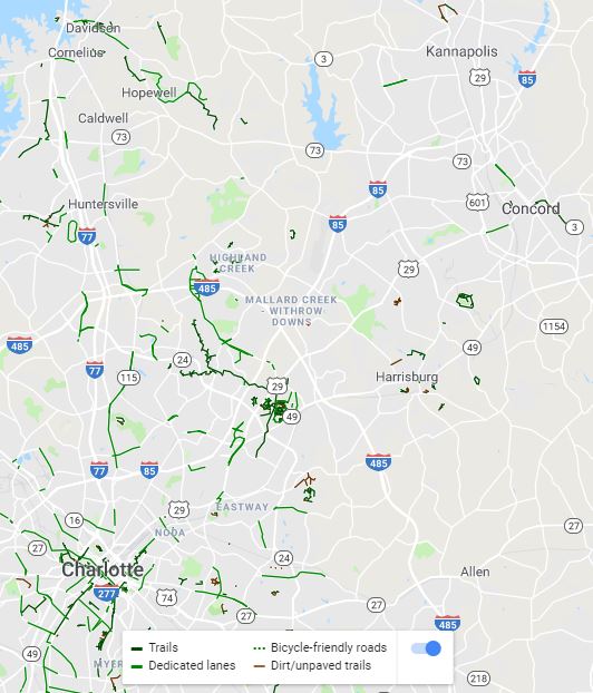
Do riders use trails more than bike lanes in Clackamas County?
Since I live and work in Clackamas County, which is located south of Portland, I focused on what infrastructure Clackamas County scooter and bike riders likely will use to travel. The region’s first scooter pilot program was legally limited to Portland and Portland did not release a map showing scooter rides south of Portland, so I do not have scooter data in Clackamas County yet. Scooter riders typically use the same infrastructure as cyclists, so I analyzed where cyclists currently ride in Clackamas County (left map). While bike lanes exist in Clackamas County, cyclists mostly use trails. In case you are not familiar with the trails, the trail system (right map) shows the same area as the left map. Since I believe all of the regional trails within these maps prohibit e-scooters and e-bikes, how will the jurisdictions that manage these trails approach enforcing their prohibitions? Will they change their policies to allow e-scooters and e-bikes?
Bike trips are mostly along trails. Source: Ride Report
Solid green lines are existing trails. Source: Metro
Legal Issues in Washington, DC Region
The legal issues are not limited to the Portland region. Since I lived and worked on transportation issues in the DC region last year, I have been following the legal issues in the DC region. NOVA Parks, which owns and operates many trails in Northern Virginia, unanimously amended their rules in March 2019 to allow e-bikes on trails such as the popular Washington and Old Dominion (W&OD) Trail. Across the Potomac River in Maryland, the Montgomery County Planning Board is considering whether to allow e-bikes and e-scooters on county trails. Dockless e-bikeshare and e-scootershare and Capital Bikeshare Plus (e-bikes) already exist in Montgomery County, but people have been riding on county trails even though it is not legal. The DC region has many more jurisdictions, so the legal issues are not resolved yet. Are you seeing similar legal issues where you live?
Thursday night I was pleased to support new NOVA Parks rules that will allow electric power-assisted bicycles (e-bikes) on NOVA Parks Trails, such as the W&OD. The unanimous vote of the Board followed a detailed study by NOVA Parks Staff & a public hearing. @NOVA_Parks@WABADCpic.twitter.com/AcZblZLSe5
Yes, you read the title of this post correctly. I am currently living car-free in the American suburb of Oregon City, which is located at the southern edge of the Portland, OR region.
Oregon City is located at the southern edge of the Portland region. I live and work in southern Oregon City. Source: AARoads
I will admit that I did not envision living and working in a suburb similar to my childhood hometown of Kannapolis, NC when I moved from Kannapolis to Charlotte in August 2009 to start undergrad at UNC Charlotte. Since I hated feeling forced to drive an automobile for every trip in Kannapolis and loved the freedom of many transportation choices in Charlotte, I never imagined returning to a suburb after graduating from UNC Charlotte. As I hope this post shows you, returning to a suburb may have been the best decision for my career.
While I still prefer living in an urban area and miss living in Arlington, VA’s award-winning Rosslyn-Ballston Corridor, I feel I am making a much bigger difference working in the suburb of Oregon City than I could have made working in a big city. This is mostly because I am the only transportation planner at Clackamas Community College (CCC) and one of the few active transportation planners in Oregon City.
I worked or interned in Charlotte, Philadelphia, Portland (OR), and the DC region, so I am confident that if I worked in a large city I would be in a large transportation department with many staff working on active transportation planning issues. While I am not trying to devalue the work that planners do in big cities, especially since they have to work on more complex issues than I have in Oregon City, how much difference does EACH of these planners have in creating change in their big city?
Since I am an entry-level transportation planner, I keep thinking about how much more difference I am making in Oregon City than I could have made as an entry-level transportation planner among many entry-level transportation planners in a big city. While I have to get permission to do things like apply for grants, I have been given plenty of professional freedom so far to pursue what I feel would be useful for improving multimodal transportation choices at CCC. This also means that I have to be more responsible for the decisions I make because I am the only transportation planner. Since I was micromanaged at a previous job (purposely not giving specifics because I do not want to embarrass a previous employer) and this overwhelmed my supervisor and me, I am thankful my current supervisor is not micromanaging me.
While I wrote earlier how Oregon City is a similar suburb to my childhood hometown of Kannapolis, Oregon City has much better active transportation access to Portland than Kannapolis has to Charlotte. After biking from my home in southern Oregon City to Downtown Oregon City on almost completely connected bike lanes, signed bike routes and sharrows, I can ride on almost completely connected trails all the way to Downtown Portland. The regional version of the below trails map can be found here. I actually helped create this map during my internship at Oregon Metro.
Regional trails between Oregon City and Downtown Portland. Source: Oregon Metro
The below map shows most of the bike infrastructure between Oregon City and Downtown Portland. Since Portland’s famous neighborhood greenways and Oregon City’s signed bike routes and sharrows aren’t shown at this zoom level, I wanted to note that this is missing from the below map.
Bike infrastructure between Oregon City and Downtown Portland. Source: Google Maps
Unless I rarely wanted to visit Charlotte or spend lots of time and money on transferring between multiple transit systems in the Charlotte region (I can take unlimited trips on TriMet’s light rail lines and buses throughout the Portland region for $5/day), I could not have lived car-free in Kannapolis. While the Carolina Thread Trail is working to connect trails throughout the Charlotte region and I volunteered to help create the Carolina Thread Trail Map, it is not possible today to use trails or any other bike infrastructure to bike between Downtown Kannapolis and Uptown Charlotte. Since Charlotte’s bike lanes, signed bike routes and sharrows are not shown at this zoom level, I wanted to note that this is missing from the below map.
Bike infrastructure between Uptown Charlotte and Downtown Kannapolis. Source: Google Maps
Oregon City has good biking and transit access to Portland, so I have been able to visit Portland frequently without driving. While some people in Oregon City have suggested I should buy a car so I can travel quicker, owning and maintaining a car is expensive. Plus, my job literally involves helping people to reduce car dependency. I can currently motivate people to reduce car dependency by telling them that it is possible to live car-free in a suburb like Oregon City because I live car-free here. How would they react if I told them I gave up and purchased a car for the first time in my life?
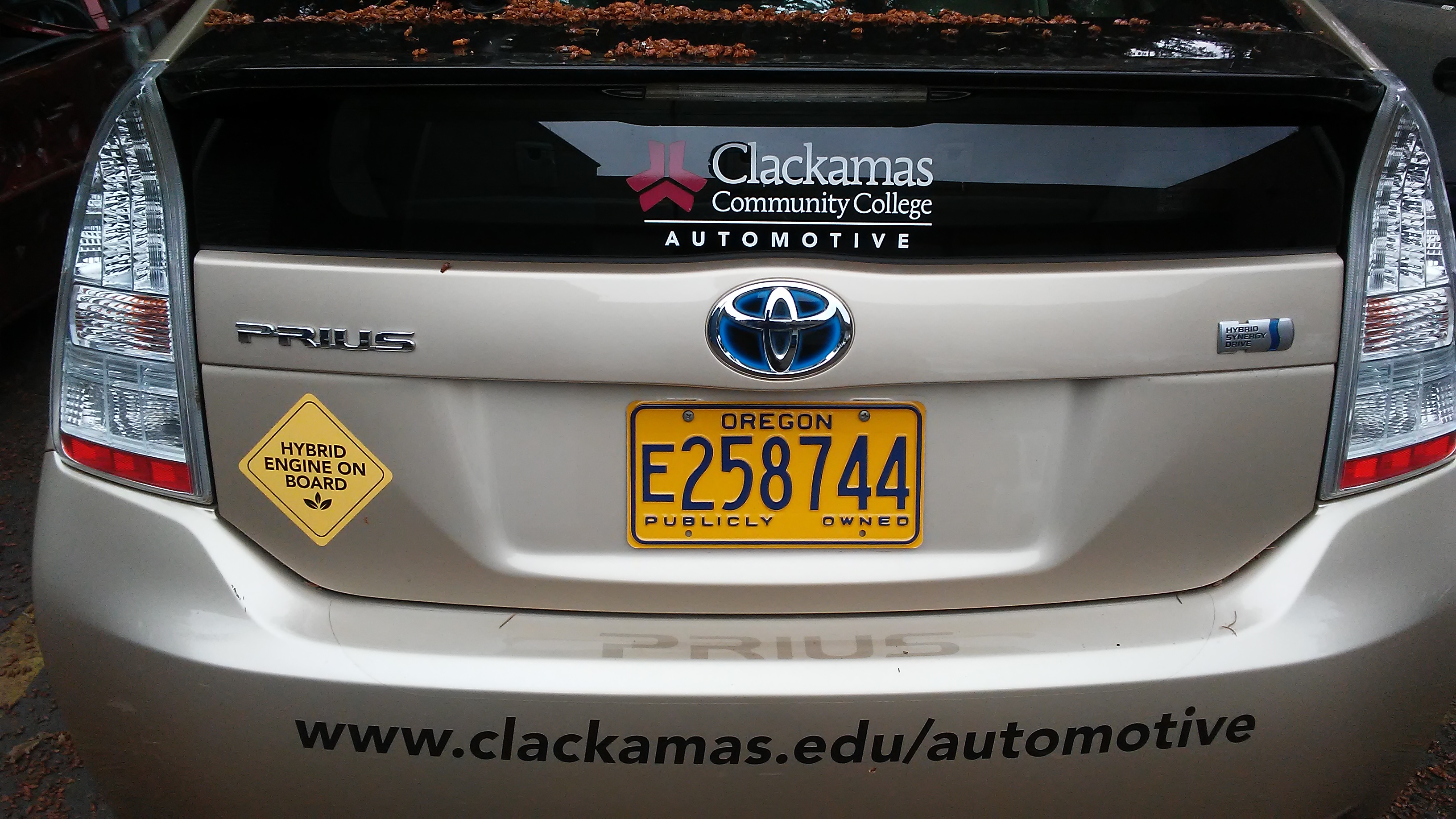
While I live car-free in my personal life, I cannot reach all my work trips by walking, biking and riding transit. Since I did not want to buy a car for work trips, my supervisor helped me reserve the below hybrid electric car, which CCC owns. This car is only available during the summer term because students learn how to reconstruct the car during other terms. Due to this, I have had to use expensive transportation network companies like Uber and Lyft to travel for work trips during the rest of the year. Even though I was nervous about whether my supervisor would support my car-free lifestyle, he has been very supportive.
I have so far driven the hybrid electric car to and from the Clackamas County Coordinating Committee (C4) Meeting near Mt Hood. Since this was the first time I drove after moving back to Oregon and I didn’t drive much when I lived in Virginia, I had to adjust to driving again. I have always been a slow driver, but Oregon drivers have been proven to be among the nation’s slowest drivers so I fit in.
Hybrid electric car provided for work trips. Photo: Ray Atkinson
As my below Instagram post shows, the C4 Meeting provided me with good insights into Clackamas County’s transportation priorities. Unfortunately for my work to reduce car dependency, widening I-205 is definitely the top priority. Oregon DOT (ODOT), which presented about the I-205 toll and widening project during the C4 Meeting, has been trying to get support for widening I-205 by saying this will reduce traffic congestion. While traffic congestion may be reduced in the short-term, induced demand has shown that widening highways never reduced traffic congestion in the long-term. This is why ODOT needs to use the I-205 toll revenue to fund active transportation projects, which have been proven to reduce traffic congestion on highways. If ODOT is looking for an existing program to review, I recommend the I-66 Commuter Choice Program because revenue from the I-66 toll in Northern Virginia is directly funding active transportation projects in Northern Virginia.
I have not decided what my next blog post will be about, but it will probably be something about what I am experiencing in Oregon. Thank you for reading my blog!
While adjusting from being a full-time graduate student to my first full-time, permanent job over the past six months has been a learning experience, my toughest learning experience has actually been learning how to still be an advocate without risking my dream job. In a perfect world, “I’m speaking as a resident of Arlington County and not as a consultant for Arlington County” should be enough for me to keep being a vocal advocate without risking my dream job. As this post shows, my first documented time of being a vocal advocate was in January 2009, which was during my senior year of high school. Since we don’t live in a perfect world, I need to be more careful of how I approach my advocacy work.
This interview with a local reporter about a new Capital Bikeshare station at the Shady Grove Metro Station is a great example. I told the reporter that I was only willing to be interviewed if he interviewed me as a cyclist and not as a consultant for Montgomery County. Even though the reporter followed through on my request, my boss asked me to not do any more interviews and to refer reporters to the County’s Public Information Officer. My boss also said I represent MetroBike, Capital Bikeshare, and our clients at all times, so it doesn’t matter whether I tell the reporter to interview me “as a cyclist and not as a consultant for Montgomery County”.
Source: Ray’s interview with Michael Gordon
While my boss has trusted me to understand how to be a careful and aware vocal advocate at public meetings, my friends and family have suggested that being a vocal advocate isn’t worth the risk of potentially losing my dream job. Since I agree with my friends and family, I’m experimenting with another advocacy approach that I’m calling mapping advocacy.
I’m planning to silently (no risk of being interviewed or speaking at public meeting) advocate for a better regional trail system in the DC region by using my GIS knowledge, skills, and abilities and partnering with two DC-based non-profit organizations, which are the Rails-to-Trails Conservancy (RTC) and Washington Area Bicyclist Association (WABA). WABA launched the Capital Trails Coalition in 2016 and I serve on its Analytics Working Group, so this is how I learned about the project that I’m helping to complete. Full-time employees of both non-profit organizations have offered to request additional help for our project from their organization’s volunteers, so the official name for my new advocacy work may be Public Participation GIS (PPGIS).
Since I haven’t done any complex analysis in QGIS yet, I’m looking forward to learning how to use QGIS to complete the complex analysis needed for the Capital Trails Coalition’s project. As my senior honors thesis from UNC Charlotte shows, I have done this complex analysis in ArcGIS. I no longer have free (included with tuition and fees) access to ArcGIS like I did at UNC Charlotte and Portland State University, so I’ve been learning how to use QGIS.
The below examples from my senior honors thesis show the analysis I plan to do for the Capital Trails Coalition. I plan to digitize all the regional trailheads and connect them to the walking, biking, and driving infrastructure networks. This will allow me to create multimodal service areas for all the regional trails in the DC region. I can use the service areas to do further analysis like overlaying the service areas with US Census data. This analysis will allow me to see socioeconomic issues that could be improved with better planning.