“Memphis at Eye Level: Part 2” is a reference to “The City at Eye Level”. I finally volunteered with the bike riding portion of the Urban Bicycle Food Ministry‘s program, which happens on Wednesday evening and Saturday morning. Since I am not an early bird, I was struggling for weeks to motivate myself to wake up early enough to volunteer with the Urban Bicycle Food Ministry. The Saturday morning program starts with cooking at 7am and delivers the food at 7:30am. I previously helped to cook for the Wednesday evening program. I wanted to deliver the food, but I needed to prioritize eating my own dinner. The program is during dinner time on Wednesday evening. The program celebrated eleven years this weekend.
As someone who was raised (felt forced to attend) in Bethpage Presbyterian Church, which is located in North Carolina, and now attends the Unitarian Universalists church called Church of the River in Memphis as I continue to evaluate my religious beliefs as an agnostic in the South’s Bible Belt, I actually find the video below to capture my viewpoint on religion more accurately than any traditional church video. I prefer to be outside the church walls helping my community rather than stuck inside the church walls just talking about how I could help my community. I also love how the organizer accepts anyone from any religion to volunteer. This is what a welcoming church environment should mean. I get frustrated when I see churches say that they are welcoming to only find out that they are only welcoming to people who agree with their viewpoint. I strongly believe churches should be a place where people can discuss and argue about controversial topics. Unfortunately, churches are all too often places for groupthink. I believe groupthink is how some wars were started and why some current wars have no end in sight. I hate groupthink!
Ray’s Experience Volunteering
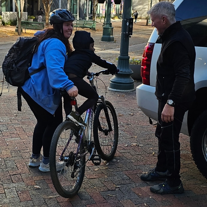
While I wish it did not take a special day to motivate me to get up early to volunteer with the Urban Bicycle Food Ministry, I finally motivated myself to wake up early when I felt the need to help veterans on Veterans Day. Unfortunately, veterans are more likely to be homeless than other Americans. I was impressed by the program’s operation. The homeless people and other struggling people that we encountered on Main Street were very aware of the program’s existence. They lined up to get a meal from me and the other volunteers. Since I was busy giving out the meals, I did not have time to get their permission to take photos. The organizers said I could take photos if I got permission from the people we were helping.
I may have broken this rule when taking the photo below. The kid got on the adult bike, and I did not have enough time to ask their parent for permission to take the photo before their kid got off the bike.
Involving Homeless People in Public Outreach Process
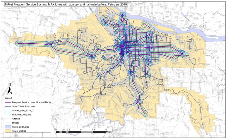
As I was volunteering, I kept thinking about how I rarely see homeless people in public outreach processes. While I will admit that I want biking and walking to be viewed as something that everyone does and not just low-income people, I realize that currently biking and walking for transportation in Memphis appears to be mostly done by low-income people. I should clarify that I specifically included “for transportation” because I have mostly seen wealthier people in Memphis bike and walk only for exercise. I usually see these people drive for transportation. I hope my work encourages these people to also bike and walk for transportation and view biking and walking as normal modes of transportation. I enjoyed seeing this when I studied abroad in Denmark and the Netherlands. Most people in these countries viewed biking and walking for transportation as normal parts of their culture.
As I try to change the walking and biking cultures in Memphis, I am concerned about how to get homeless people and others struggling on the street involved in my public outreach processes. Since they likely do not have computer or internet access, they likely are not aware of public outreach meetings. I likely will have to go to them instead of expecting them to come to a usual meeting room. Due to my limited budget, I am not suggesting that my program will always be able to do special engagement activities for people living on the street. I mostly wanted to share how this population is often excluded by typical public outreach approaches. Do you think that my program could partner with the Urban Bicycle Food Ministry to organize mobile public outreach activities?
Future Blog Post
I think a great opportunity to experiment with innovative public outreach approaches will be during the City of Memphis’ Safe Streets and Roads for All (SS4A) Action Plan creation process, which kicks off this month. Since the USDOT website publicly shares the grant amount, I can share that this action plan has $800,000 worth of federal and local funds. I view the homeless population and other vulnerable low-income street users as critical people to be involved in this planning process. I doubt the typical email and snail mail notification approaches and public outreach strategies will be effective at involving this population, especially due to the fact that they do not have an email address or physical mail address. Have you seen innovative approaches to notify and engage homeless people in your planning process?