Memphis at Eye Level: Part 1

“Memphis at Eye Level: Part 1” is a reference to “The City at Eye Level”. I want to highlight my favorite Memphis bike route so far. I realize that I have not explored every Memphis neighborhood yet, so I may find a new favorite route. As I stated during my interview with Tulio from the Memphis Hightailers Bicycle Club, I have been pleasantly surprised by Memphis’ bike infrastructure across the Mississippi River at the Big River Crossing and between Downtown and Shelby Farms Park.

Instagram recording is https://www.instagram.com/p/Cywr50UgYrR/
Facebook recording is https://www.facebook.com/MemphisHightailersBicycleClub/videos/6620980434622801
Zoom recording (passcode !!S0H!R^) is https://us02web.zoom.us/rec/share/TWI8YeuVcb3CaZh7qVLMJ2qIk-f1DMuqUCBAk8HSezAKddvGfq4YQYchVPlmdBA.wP19ToM8Q4j7Xj6F

I am thankful to work with coworkers who value my passion for active transportation. I treasured receiving this handwritten letter from Matthew more than receiving an email.

Handwritten letter from Ray’s coworker

Ray’s Favorite Memphis Bike Route

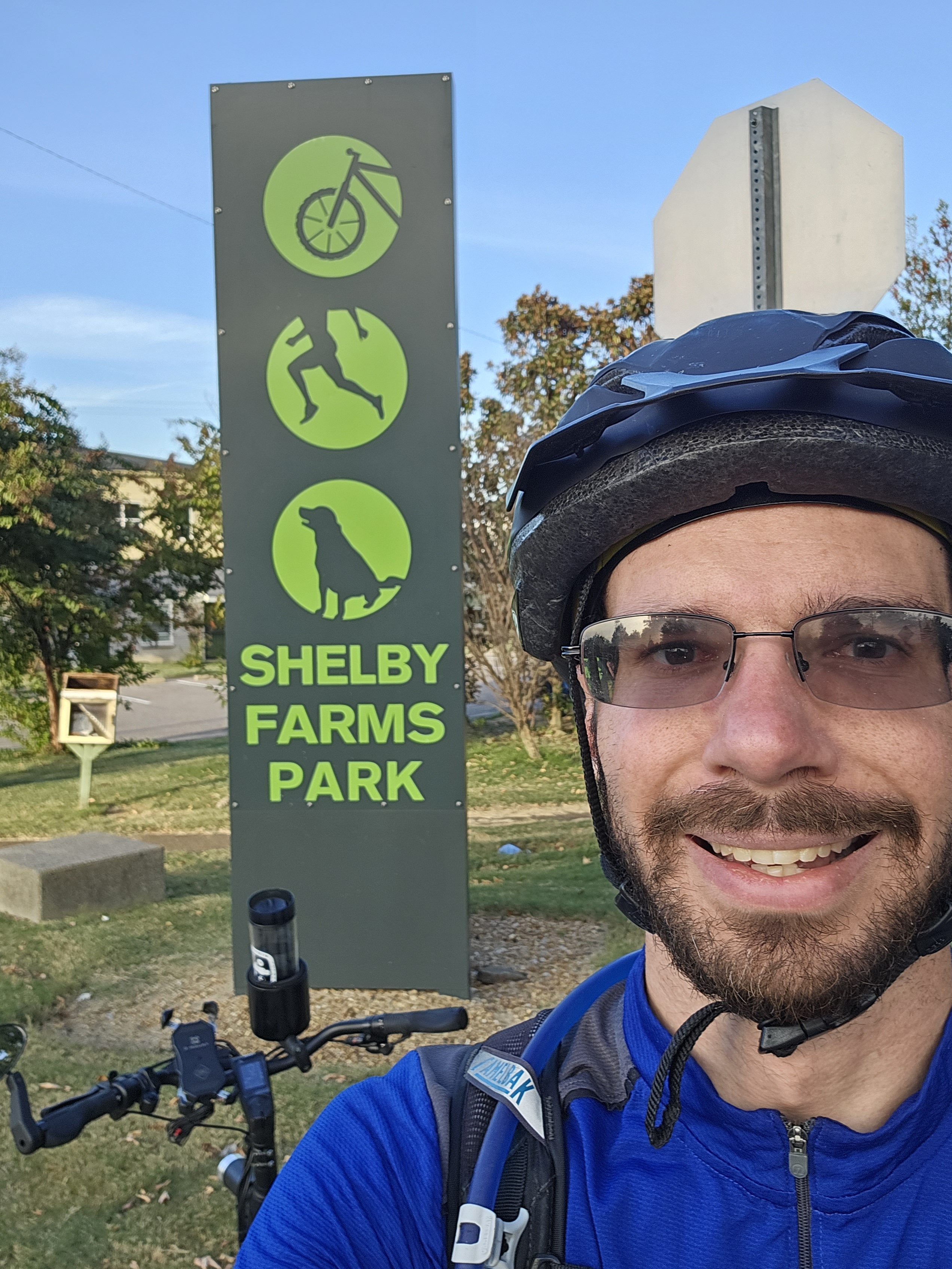
I wish that I had stopped to take more photos while biking because my usual “The City at Eye Level” post is not going to be as visual as I prefer. At least I can share a map of my favorite Memphis bike route. Yes, it takes about 90 minutes. I usually stop on the way for a meal and to do errands. I enjoy the variety of bike infrastructure, which starts with speed bumps on Front St, protected bike lanes on MLK Ave, bike lanes on Peabody Ave and McLean Blvd, low-volume side streets on Jefferson Ave and Tucker St to more easily access Overton Park, wooded car-free roads in Overton Park, multi-use trails called the Hampline and Greenline, and ends with wooded trails in Shelby Farms Park.

Ray’s favorite Memphis bike route. Source: Google Maps

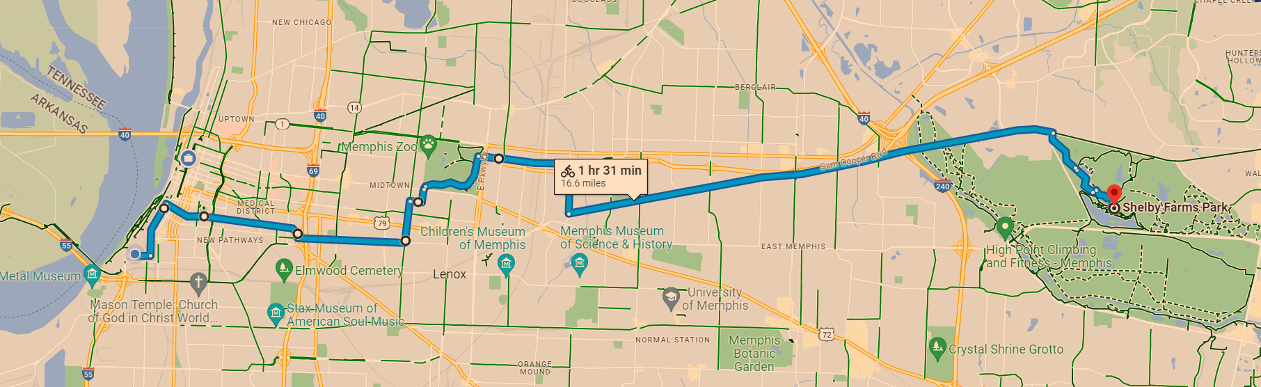
Yes, I wish Peabody Ave connected directly to the Greenline when I am in a rush. However, I do not mind the extra distance through Overton Park too much because I enjoy forest bathing in Overton Park. As this map shows, there are plans to extend the Greenline closer to Peabody Ave. The Shelby Farms Greenline Western Extension should be connected to the South Memphis Greenline Phase 1 someday. An on-street connection will likely be needed to safely connect these future extensions to Peabody Ave. I should clarify that this is my personal opinion and not the opinion of the City of Memphis’ Bikeway and Pedestrian Program, which I manage. Do you see the South Memphis Greenline Phase 1 in the bottom left corner and how it could someday connect to the Shelby Farms Greenline?

In addition to improving the active transportation networks in Memphis, I am also looking forward to improving the City’s bike map to make it more user-friendly. For example, I want to make it easier for people to find safe routes and bike shops that will work on e-bikes. As an e-bike owner, I recommend All About Bikes. In case the bike shop is located too far, I also recommend Velotooler, which is a mobile bicycle service. I am located far from All About Bikes, so I have been trying to improve my bike repair skills. Since it is tough to change an inner tube without help, I was thankful to have a Memphis friend help me when I got a flat tire. I now carry everything on my bike that I need to change an inner tube without needing to stop at a bike shop. I still support bike shops, especially local shops, but they are not always nearby when I get a flat tire.

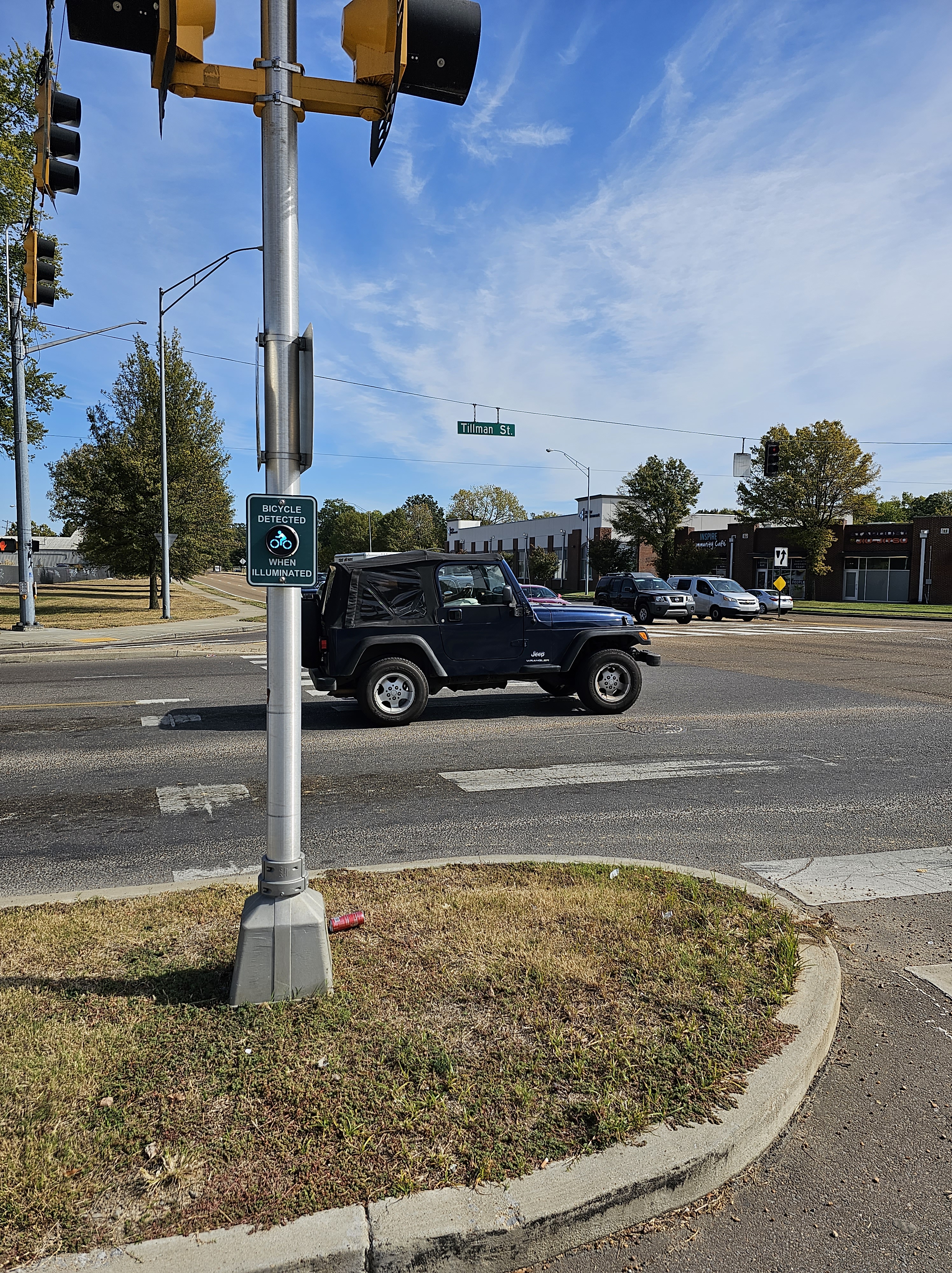
I also want to spotlight the importance of signals in creating safe active transportation networks. While the above map does not show bike-specific signals, I have found these signals helpful. The below bike signal is in Memphis on the Hampline at Tillman St as it crosses Sam Cooper Blvd. I would love to take this signal to the Dutch standard by adding a wacht signal (wacht is Dutch for “wait”). As I showed in this 2015 post from when I studied abroad in the Netherlands, the wacht signal allows people biking to see how long the wait time is for the signal to turn green. Since the Dutch standard is usually not legally allowed in the US, I was excited to see Portland (OR) install a wacht signal in 2015. I was actually in Portland when this signal was installed. I got to experience using it when I biked in Portland. I realize that Memphis has a unique culture and may not want to copy what Portland does. I look forward to collaborating with Memphians to create a unique approach that accomplishes the same goal of improving bike signals in Memphis.

Do you see the “bicycle detected when illuminated” signal on the Hampline at Tillman St as it crosses Sam Cooper Blvd? Photo: Ray Atkinson
The “bicycle detected when illuminated” signal coordinates with the bike signal on the Hampline to cross Sam Cooper Blvd in Memphis. Photo: Ray Atkinson

My favorite artistic part of the Hampline is the upcycled tires that are found on Broad Ave, which is just north of Sam Cooper Blvd. The photo below does not show the upcycled tires well, so I need to take a zoomed in photo when I bike on Broad Ave again. The upcycled tires are produced by locals at the Binghampton Development Corporation, which has an inspiring process of hiring at-risk locals. I got to tour their process during the Binghampton Tour. I tweeted (does X still call them tweets?) from the Bike Ped Memphis account during the TAPA Conference.

Photo of upcycled tires on the Hampline during the Binghampton Tour. Photo: Ray Atkinson

Improving How Ray Navigates While Biking

Even though I majored in Geography at UNC Charlotte and love studying maps, I will admit that I sometimes struggle to navigate Memphis without looking at a map. Due to this issue, I decided to back this $700 Kickstarter for Minimis’ augmented reality (AR) glasses. Assuming the glasses are shipped on time, I should receive them by next summer. I am looking forward to publishing a blog post about my experience using the expensive glasses!

Minimis Glass Prototype video. Source: Minimis

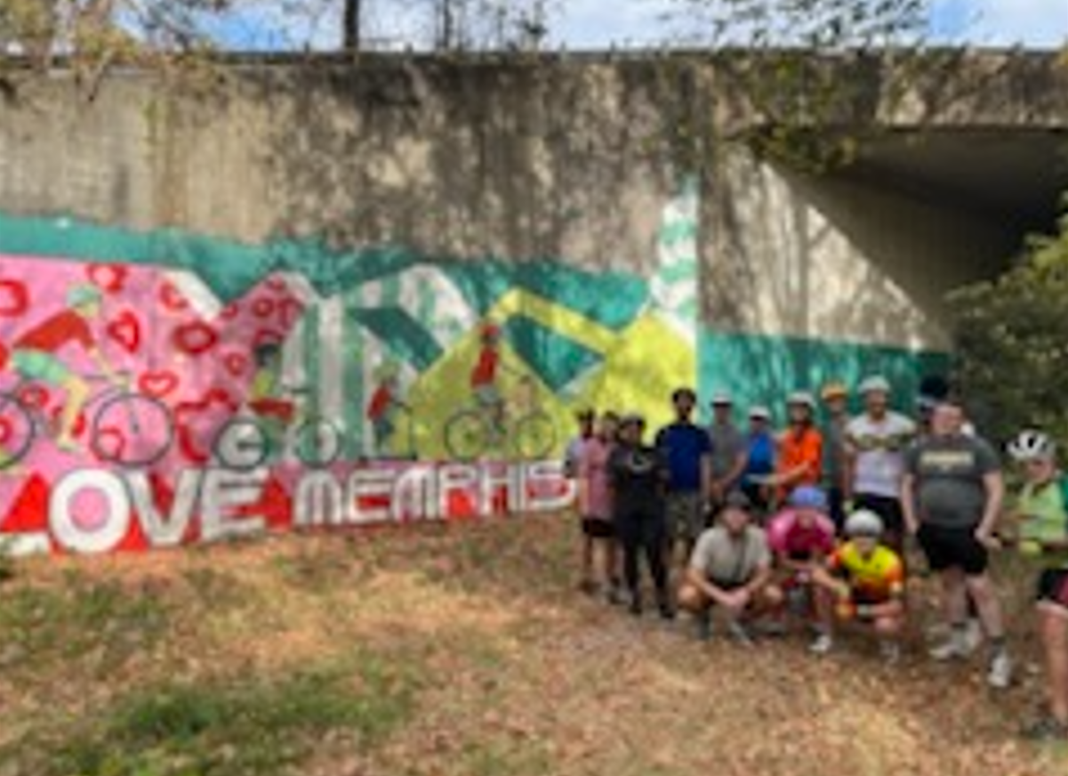
Since I prefer to socialize when biking, I am thankful that I have been invited to participate in several slow group rides in Memphis. The below ride along the Greenline was unique because it was the first large group ride organized by City of Memphis employees. While I did not feel comfortable taking photos of kids during the Carpenter Art Garden’s kid-friendly group bike ride, I also had an amazing experience helping to lead this weekly group bike ride along the Hampline and Greenline. One of the kids actually hugged me after the ride to thank me for helping!

Hopefully, someone took a high-quality photo!
Biking the Greenline in Memphis. Photo: Ray Atkinson

Future Blog Post

I was originally planning to write about my experience volunteering on the Urban Bicycle Food Ministry’s weekly bike rides. Since I have not participated in the Wednesday evening or Saturday morning ride yet, I will need to postpone blogging about this experience.

Remembering Legendary Kannapolis Historian Norris Dearmon and Happy 10th Anniversary to My Blog!

I was originally planning to write a quick memorial post about legendary Kannapolis, NC historian Norris Dearmon, who died yesterday at 100 years old. He had a long and impactful life. Since I volunteered with his son, Eric Dearmon, I am keeping him in my thoughts as I remember his father. As the below photo shows, I was fortunate enough to learn from Norris while I was creating my senior exit project at Northwest Cabarrus High School in 2009. My project was titled the Impact of the North Carolina Research Campus on Kannapolis. Norris and I shared our love and passion for history and maps. Mrs. Andersen, I know you read my blog. Thank you for being my senior exit project advisor!

Ray looking at a historic photo of Kannapolis, NC from the mid-1900s with legendary historian Norris Dearmon at the Kannapolis Library in 2009 for Ray’s high school senior exit project

While I have not been blogging long enough to have included my high school experiences when they happened, WordPress surprised me with the below Happy 10-Year Anniversary when I logged in tonight. I made it to 10 years! On the 10-year anniversary of my blog, I think Norris would have been proud of how I have continued to promote the value of learning history.

As I write this post in Petaluma, I find it interesting to reflect on the fact that I had not even heard of Petaluma when I started my blog in 2014. While I pride myself on being a geographer who knows where places are located, I also did not even know the location of Petaluma within California when I lived in Oregon. My blog has been through an international geographic journey. I am excited to visit and blog about more places around the world!

I try not to be jealous, but I think it would have been fun to celebrate this achievement in a similar fashion to how BikePortland’s supporters celebrated the 10-year anniversary of BikePortland.org in 2015. Yes, I realize BikePortland has more readers and active engagement than my blog. We have different blogging styles. I prefer using my blog to write my autobiography for me and my future family. Since I am very curious about how my future wife and kids will react to my blog, I hope that I have the opportunity to get married and have kids.

Future Blog Post

Here is to the next 10 years of my blog! What is your favorite post from my first 10 years of blogging?

History Is Important When Thinking About The Future

I want to write a quick follow-up post about this Windsor post because I remembered some fascinating historic maps that are in the Petaluma Historical Library and Museum. I visited this museum with a friend today. As the below 1912 map shows, West Windsor used to be served by an agricultural railroad. I need to research whether people were allowed to ride the agricultural train or if the train was only for commercial shipping. Either way, the train no longer exists. I assume car dependency and the shift from railroad shipping to truck shipping caused the trains to no longer exist. I need to research this further to avoid making bad assumptions. I know for certain that Petaluma’s history as being the “Egg Basket of the World” resulted in the need for shipping the eggs. Since this industry is no longer as large in Petaluma, there is no longer much need for shipping eggs.

Regarding how this history relates to the future, the Sonoma-Marin Area Rail Transit (SMART) is working to bring back train service to serve people in Windsor. I am often surprised by how many locals do not know their own local area or state’s history. Since I enjoy studying history, I frequently end up educating them about their own local and state history even though I am not from California. How many locals in Windsor do you think know that West Windsor used to be served by an agricultural railroad?

Photo: Ray Atkinson

While the below 1923 map is not related to Windsor unless you want to count that the train service went to Windsor, it surprised my Unitarian Universalists of Petaluma friend who has lived in California most of his life that Petaluma used to be served by so much train service! Look at all the train routes that used to serve Petaluma! The only remaining train route, which was operated by a different company in 1923, is the route served by SMART. I actually need to research whether the train tracks that SMART currently uses through Petaluma were continuously operated since 1923. I have a feeling that SMART may have restarted service in 2017 on a disused rail line.

Photo: Ray Atkinson

Future Blog Post

Since no one has replied to the questions in my last post, I copied the questions below. While I would enjoy having people comment on my posts, I am mostly writing this blog for my autobiography and for my future wife and kids to read. Assuming I ever get married and have kids, which feels less likely to happen as I am getting older and my future wife is unable to have kids when she reaches menopause, I am looking forward to telling them stories as I reflect on my car-free life. I hope I am not sharing too much. I have been thinking about how I prefer to develop romantic relationships slowly. This likely means that being at the point in my future relationship with my future wife to have kids will take years.

Do you understand the connection between The City at Eye Level and my recent posts about the power of slowing down and its impact on creating robust outdoor in-person social networks? If not, I will keep thinking about how to more clearly write about and show this connection in future blog posts. If so, what other topics do you want me to write about?

How Petaluma’s Food Desert And Transportation Access Issues Impacted Ray’s Housing Search

Since I am feeling triggered by seeing my last post, I feel the need to add a more pleasant post sooner than I normally would. I am writing this post on my phone, so this will be a short post. I may expand on the post when I am back on my laptop. I was reviewing my 50 draft posts when I found this post about food deserts. Before I share a Petaluma-specific example, do you agree with this article that advocates for people to stop using “food desert”?

Due to how important food deserts and transportation access to grocery stores were to my housing search, I was planning to show maps of what I believe are Petaluma’s food deserts. I decided not to add the maps because I do not want my former roommate to stalk me again. I ended up avoiding a slightly cheaper studio apartment near Casa Grande High School because there are no healthy grocery stores within walking or biking distance of the studio apartment. The slightly more expensive studio apartment that I moved to in February is within walking and biking distance of healthy grocery stores.

Finding Ways To Relax During Mental Health Recovery

I wanted to share a few ways that I am relaxing during my mental health recovery. I went to my first kirtan concert on Saturday night. The video below shows what a kirtan concert is. While I usually prefer to bike because biking is faster than walking, I have been walking more recently to relax. Due to how loud automobiles are, I wish Petaluma was quieter to take walks in. I may have to bike to a nearby rural park to access a quiet enough place to walk. Do you also struggle with finding a quiet place to walk and relax? If so, how have you tried to find a quiet place?

https://www.instagram.com/p/Co5n__eyM0Z/?igshid=MDJmNzVkMjY=

Future Blog Post

In addition to what I am planning to do from my last post, I also want to write about my next car-free vacation plan. While this plan is not set yet, I need a vacation after my recent stressful experience. Since I do not want to wait until my next vacation to explore more of California, I have been planning and enjoying daycations and weekend getaways with friends in California.

Walking and Biking in the New Normal

I did not expect to write this post when 2020 started. This shows how quickly the coronavirus has impacted our lives. I wish I knew when the new normal would start so I could create some consistency in my life. While I am not sure how many months physical distancing will last, it appears that physical distancing will shape the new normal. Since I have struggled to maintain at least six feet from other people when walking and biking, how can tactical urbanism be used to quickly and cheaply create spaces that allow people to maintain at least six feet from other people when walking and biking?

What is the issue?

Before share how my question could be answered, I want to make sure you understand the issue that I have been experiencing. Spencer Boomhower at Toole Design Group created this video that shows the issue.

Source: Spencer Boomhower at Toole Design Group

While I do not live in Portland, I have experienced similar physical distancing issues when I visit Portland. Portland’s Safe Streets Report shows some of the major challenges that the Safe Streets Initiative is trying to resolve. The below four issues match four numbers on the below photo.

  1. a need for additional space for walking
  2. a need for wider sidewalks
  3. transit stops without space to safely wait for the next bus
  4. a need to reinforce physical distancing guidance to support local businesses
Source: Portland Safe Streets Report

I believe maps are also a great way to show the issue. I found sidewalk width maps for New York City and Washington, DC. I used to live in the DC region, so I am more familiar with the DC map. As the below map shows, many sidewalks in one of the most walkable cities in the US are too narrow for physical distancing.

While I thought about using Level of Traffic Stress (LTS) maps to show whether bike lanes and trails are also too narrow for physical distancing, LTS analysis is not limited to bike lane and trail width so the LTS maps would not have been accurate for showing whether more space is needed for physical distancing. Due to this, I decided to show the below graphic from this International Transport Forum COVID-19 Transport Brief. The red lane on the left shows the pre-coronavirus existing bike lane. The red lane on the right shows how much space is needed to provide people with enough space for physical distancing.

How can tactical urbanism be used to resolve the issue?

While a long-term solution could be widening sidewalks, the coronavirus is killing people today due to the lack of space to physically distance from other people. I believe quick, inexpensive tactical urbanism projects are needed to resolve this emergency issue. As the below graphic shows, Portland’s Safe Streets Initiative shows how tactical urbanism projects can be used to resolve the emergency issue. Hopefully, some of these short-term projects are converted to permanent projects.

Since I have not seen a Safe Streets Initiative in any Oregon suburbs, I hope Portland’s initiative will encourage other cities throughout the Portland region to create safe spaces for people to do physical distancing. I have been advocating for Oregon City, which is where I live and work, to create a Safe Streets Initiative so I can safely do physical distancing when I am walking, biking, and waiting for the bus. I have learned through my advocacy work that people in suburban cities frequently say “we are not Portland” or “we do not want to become Portland”. Due to this, do you know of any suburban cities that have implemented a Safe Streets Initiative?

Future Blog Post

The coronavirus is also impacting my vacation plans. I was hoping to visit South America for the first time on this two-week Colombia trip. Since the coronavirus forced Colombia to lockdown, I have not scheduled my Colombia vacation yet. Due to being furloughed every Friday until the end of July (extended to Labor Day if the laws get extended) because of the economic crisis created by the coronavirus, I actually have no summer vacation planned because I would be ineligible to receive unemployment benefits from the CARES Act and Oregon Work Share if I took a vacation. While I am nervous about doing my first workation, I plan to continue working remotely as I visit family and friends in Colorado, North Carolina, and Minnesota from after work on July 9-August 2. What would you like to see me write about during my workation?

Silver Lining As Transit Plan Process Is Impacted By Coronavirus

I cannot believe this is my first post of 2020! Since I was supposed to be taking the American Institute of Certified Planners (AICP) Certification Exam again on May 23, I was not expecting to have time to blog again until after May 23. Due to the coronavirus, my exam was postponed until sometime later this year. While I am hoping that it is postponed until November, which is when the next exam is normally scheduled, my postponed exam date has not been scheduled yet. This means I can start planning a long summer vacation and continue blogging until I need to focus on studying again.

The coronavirus is impacting many people throughout the world. If this global pandemic is anything like the 1918 influenza pandemic (I will not refer to it by the racist name, especially because the flu likely did not originate in Spain) then the second wave of the coronavirus could be worse than the first wave. While I am trying not to be too political, I am concerned that the Trump Administration will prioritize restarting the economy over health concerns. Restarting the economy too early could result in a second wave of the coronavirus. Before I share how my transit plan process is being impacted by the coronavirus, I am thankful to be healthy and alive when thousands of people are dying from the coronavirus. I am also thankful for people who are risking their lives to prevent the pandemic from becoming worse.

What is my silver lining?

My silver lining is having the opportunity to experiment with conducting a fully remote student outreach process for Clackamas Community College’s first-ever transit plan! Since I am concerned that students will not engage as much through remote outreach environments as they would have through in-person outreach environments, my silver lining could still have negative results. As a silver lining for my silver lining, my consultant team and I will know how to improve our remote outreach process in the future.

I will admit that I was unsure whether it is feasible to complete the transit plan that my consultant team and I started working on in January before the global pandemic is over. This is mostly due to the fact that I have never done a fully remote outreach process for a planning project. Many other planning processes have been delayed by the coronavirus. While I asked my consultant team whether the completion of their spring term classes and June graduation from Portland State University were going to be delayed because of the coronavirus, nothing ended up being delayed so the transit plan still has to be completed by June 8.

Due to the fact that many students do not have access to reliable internet and computer access at home (CCC’s computer labs and all libraries are closed), especially in rural areas, I have been very concerned about excluding many historically marginalized communities from the student outreach process for the transit plan. While the 200 Chromebooks given to students at the start of spring term does not resolve this barrier, it allows more students to continue their classes and participate in my outreach process.

As the below work plan from March 11 shows on pages 14-15, the entire student outreach process was going to be through in-person environments. I still cannot believe the work plan was only created a month ago! Since all campus buildings are locked for the foreseeable future, CCC Xpress Shuttle service (plan is focused on CCC Xpress Shuttle) is shutdown for spring term, all spring term classes are online or canceled because they were not able to be offered online, and my consultant team and I have to work from home, the entire student outreach process was quickly converted to remote environments.

My consultant team used creative skip logic in the online survey that they created in Qualtrics. Due to this, I had difficulty deciding which remote outreach tool I am most excited to learn how to use. Since my consultant team created the online survey and I am creating the Remix map for our presentation to the Associated Student Government (ASG) at their May 6 meeting, I am most excited to learn how to effectively use Remix for remote outreach. As the below screenshot shows, Remix allows students to submit comments about the proposed new CCC Xpress Shuttle stops.

Preparing to use Remix for remote student outreach

Future Blog Post

While the coronavirus may impact what my next blog post is, I plan to update you on how the fully remote outreach process went. I plan to also share the completed transit plan. Since the revised Memorandum of Understanding for the revised outreach process was just signed last week, I cannot believe that my next blog post will likely be about the transit plan being done. In case you are wondering, a real-world transit plan is not usually completed in five months!

Deploying and Rebalancing Dockless Bikeshare and Scootershare to Suburban Areas

I have a love-hate relationship with urban areas. While I love the urban lifestyle, I hate how challenging it has been to expand transportation services to suburban areas. As I wrote in this 2019 post, most of the focus throughout the US to plan for dockless bikeshare and scootershare has been on the largest cities. Even if governments in the Portland region want to expand the focus to suburban areas, are companies willing to expand to suburban areas?

Portland, OR Case Study

East Portland is a suburban area that the Portland Bureau of Transportation (PBOT) acknowledged in its 2018 E-Scooter Findings Report has “historically been underserved by the transportation system”. Since I will be referring to East Portland throughout this case study, please review the below map to make sure you know where East Portland is. As the other below map shows, East Portland has above average numbers of low-income people and people of color.

As the below scooter pilot fee schedule shows, one tool PBOT used to entice companies to deploy and rebalance scooters in East Portland was charging companies less for scooters that were located in East Portland. Companies were charged more for scooters that were located in urban areas like Central City.

To align business practices with Portland’s equity goals, PBOT also required companies to deploy at least 100 scooters or 20 percent of their fleet (whichever is less) in East Portland and offer a low-income fare. Only one company, Bird, complied with the East Portland fleet deployment requirements. Both Lime and Skip deployed below 90 percent of the minimum required scooters on average throughout the pilot. Companies only enrolled 43 Portlanders in the low-income plan. Along with Portland staff observations, this suggests low company performance in aligning business practices with Portland equity goals.

Only one company, Bird, complied with the East Portland fleet deployment requirements.

Source: 2018 E-Scooter Findings Report

While only Bird complied with the East Portland fleet deployment requirements, 243 scooters (9.8 percent of the total fleet for all three companies) were deployed to East Portland. 44,155 trips originated in East Portland during the first pilot period. This demonstrates the demand for additional transportation options. Since East Portland has suburban land uses compared to urban land uses in Central City, I believe trips in East Portland averaged 1.6 miles compared to one mile in Central City because origins and destinations are further apart in East Portland.

Due to it being a pilot program, I am impressed that PBOT actually enforced the rules. Even though this article does not state why Skip has not applied for PBOT’s second pilot program, which starts on April 26, being fined during the first pilot program likely discouraged Skip.

Over the course of the pilot period, PBOT issued two penalties, both to Skip Transport, Inc. One cited failure to meet East Portland fleet deployment requirements, and the other cited failure to meet the citywide deployment requirements outlined in the administrative rule and permit. Penalties were calculated for each day the company was out of compliance after a specified deadline.

Source: 2018 E-Scooter Findings Report

Since only Bird complied with the East Portland fleet deployment requirements during the first pilot, this likely caused PBOT to reduce the requirements for the second pilot. According to this article, “A minimum of 15 percent of a company’s total scooter fleet must be deployed east of I-205 (that’s down from a 20 percent minimum last pilot).” PBOT is also using a new carrot approach during the second pilot to entice companies to deploy scooters in East Portland. Companies will be allowed to increase the number of scooters in their fleet by 35% if they meet or exceed 2-3 trips per scooter per day.

Will suburban cities use Portland’s approach?

I have been asking people that work for suburban cities whether they plan to use Portland’s approach to regulating bikeshare and scootershare companies. Even though I have expressed my concern about them waiting to create regulations, everyone has told me that they plan to wait until Portland launches their second scooter pilot to see whether they need to create regulations. Since I do not want to embarrass any of my contacts, I purposely did not share which suburban cities I have been meeting with about this topic.

As I mentioned in my last post, Milwaukie is planning to allow companies to deploy scooters in Milwaukie soon after Portland launches its second pilot scooter program. I do not have scooter data for Milwaukie and assume scooter riders will use similar infrastructure as cyclists, so I reviewed bike trip data to understand where scooter trips likely will occur. Without any regulations to force companies to deploy and rebalance their scooters in low ridership areas, I predict companies will deploy and rebalance scooters in higher ridership areas. This approach will allow companies to make the most money on their investment.

Since Clackamas Community College’s Harmony campus is located in unincorporated Clackamas County just outside the southeast edge of Milwaukie’s city limit, I am concerned that companies will not supply enough scooters to Harmony campus to make this a reliable transportation service. Milwaukie is working on annexing Harmony campus into the city so Harmony campus will be within the city limit soon. Even when this happens the above map shows that most scooter trips will be in Downtown Milwaukie, which is 3.5 miles west of Harmony campus.

I am focused on Harmony campus because scooters could be used to make the first- and last-mile connection between Harmony campus, Clackamas Middle College and Clackamas Town Center. Since the CCC Xpress Shuttle only goes in a clockwise loop from Harmony campus to Clackamas Town Center, people have asked me to find another transportation service to go from Clackamas Town Center to Harmony campus. The shuttle service is not always frequent and does not operate every day, so people also want a more reliable transportation service from Harmony campus to Clackamas Town Center.

Harmony Campus to Clackamas Town Center

Source: Created by Ray Atkinson using Google Maps

While dock-based scootershare and bikeshare systems are more expensive than dockless scootershare and bikeshare systems, I believe a dock-based system would provide Harmony campus with more reliable transportation service because suburban users would not have to worry about the bikes or scooters staying in urban areas. Since I doubt a dock-based system is a financially feasible option due to lack of public funds (assumes no grant funding), is it possible to entice companies to deploy and rebalance dockless bikes and scooters to Harmony campus without government regulations?

Importance of Trails in Planning for Electric-Assist Dockless Bikeshare and Scootershare

The following post draws on my last post and this 2018 post. As the Portland region prepares for Portland’s second pilot scooter program that starts on April 26th and Milwaukie’s first pilot scooter program that should start this spring, the most used and safest infrastructure for Clackamas County scooter riders likely will prohibit scooters. Since trails are fully separated from automobile traffic, I consider trails to be the safest infrastructure for scooter and bike riders. Unfortunately, many trails in the Portland region prohibit e-scooters and e-bikes. While Jonathan Maus at BikePortland learned that Portland does not enforce this prohibition, the prohibition still creates legal issues for e-scooter and e-bike riders. The following quotes summarize the issues.

“If the City is serious about accomplishing its goals, it needs to act soon to allow at least some level of e-bike and e-scooter access to these areas by non-disabled Portlanders.” – Chris Thomas, Portland lawyer at Thomas, Coon, Newton & Frost

“The Scooter Pilot and your question have had us looking closely at the code and the way people use (and would like to use) our public parks, while maintaining our focus on safety,” – Mark Ross, Public Information Officer at Portland Parks & Recreation

Source: BikePortland

As the below map shows, the region has many existing, planned and conceptual regional trails. While I am still researching the legal issue, I believe the only trail in the region that does not prohibit e-bikes and e-scooters is the Banks-Vernonia Trail, which is not located in Clackamas County. The State Parks Commission amended their rules in 2018 to legally allow e-bikes and scooters on paths and trails managed by the Oregon Parks and Recreation Department (OPRD). According to OPRD’s website, the only trail in the region managed by OPRD is the Banks-Vernonia Trail. While the 40-Mile Loop Trail is listed on this website, I believe local jurisdictions like Portland manage it. Since many jurisdictions manage trails in the region, I hope OPRD and Metro educate all the local jurisdictions about the legal issue. I doubt e-bike and e-scooter users are aware of the legal issue, so we need to have regional legal consistency.

Do riders use trails more than bike lanes in Clackamas County?

Since I live and work in Clackamas County, which is located south of Portland, I focused on what infrastructure Clackamas County scooter and bike riders likely will use to travel. The region’s first scooter pilot program was legally limited to Portland and Portland did not release a map showing scooter rides south of Portland, so I do not have scooter data in Clackamas County yet. Scooter riders typically use the same infrastructure as cyclists, so I analyzed where cyclists currently ride in Clackamas County (left map). While bike lanes exist in Clackamas County, cyclists mostly use trails. In case you are not familiar with the trails, the trail system (right map) shows the same area as the left map. Since I believe all of the regional trails within these maps prohibit e-scooters and e-bikes, how will the jurisdictions that manage these trails approach enforcing their prohibitions? Will they change their policies to allow e-scooters and e-bikes?

Clackamas County Ride Report

Bike trips are mostly along trails. Source: Ride Report

Clackamas County Trails

Solid green lines are existing trails. Source: Metro


Legal Issues in Washington, DC Region

The legal issues are not limited to the Portland region. Since I lived and worked on transportation issues in the DC region last year, I have been following the legal issues in the DC region. NOVA Parks, which owns and operates many trails in Northern Virginia, unanimously amended their rules in March 2019 to allow e-bikes on trails such as the popular Washington and Old Dominion (W&OD) Trail. Across the Potomac River in Maryland, the Montgomery County Planning Board is considering whether to allow e-bikes and e-scooters on county trails. Dockless e-bikeshare and e-scootershare and Capital Bikeshare Plus (e-bikes) already exist in Montgomery County, but people have been riding on county trails even though it is not legal. The DC region has many more jurisdictions, so the legal issues are not resolved yet. Are you seeing similar legal issues where you live?


Living Car-Free in American Suburb

Yes, you read the title of this post correctly. I am currently living car-free in the American suburb of Oregon City, which is located at the southern edge of the Portland, OR region.

Portland Region Map

Oregon City is located at the southern edge of the Portland region. I live and work in southern Oregon City. Source: AARoads

I will admit that I did not envision living and working in a suburb similar to my childhood hometown of Kannapolis, NC when I moved from Kannapolis to Charlotte in August 2009 to start undergrad at UNC Charlotte. Since I hated feeling forced to drive an automobile for every trip in Kannapolis and loved the freedom of many transportation choices in Charlotte, I never imagined returning to a suburb after graduating from UNC Charlotte. As I hope this post shows you, returning to a suburb may have been the best decision for my career.

While I still prefer living in an urban area and miss living in Arlington, VA’s award-winning Rosslyn-Ballston Corridor, I feel I am making a much bigger difference working in the suburb of Oregon City than I could have made working in a big city. This is mostly because I am the only transportation planner at Clackamas Community College (CCC) and one of the few active transportation planners in Oregon City.

I worked or interned in Charlotte, Philadelphia, Portland (OR), and the DC region, so I am confident that if I worked in a large city I would be in a large transportation department with many staff working on active transportation planning issues. While I am not trying to devalue the work that planners do in big cities, especially since they have to work on more complex issues than I have in Oregon City, how much difference does EACH of these planners have in creating change in their big city?

Since I am an entry-level transportation planner, I keep thinking about how much more difference I am making in Oregon City than I could have made as an entry-level transportation planner among many entry-level transportation planners in a big city. While I have to get permission to do things like apply for grants, I have been given plenty of professional freedom so far to pursue what I feel would be useful for improving multimodal transportation choices at CCC. This also means that I have to be more responsible for the decisions I make because I am the only transportation planner. Since I was micromanaged at a previous job (purposely not giving specifics because I do not want to embarrass a previous employer) and this overwhelmed my supervisor and me, I am thankful my current supervisor is not micromanaging me.

While I wrote earlier how Oregon City is a similar suburb to my childhood hometown of Kannapolis, Oregon City has much better active transportation access to Portland than Kannapolis has to Charlotte. After biking from my home in southern Oregon City to Downtown Oregon City on almost completely connected bike lanes, signed bike routes and sharrows, I can ride on almost completely connected trails all the way to Downtown Portland. The regional version of the below trails map can be found here. I actually helped create this map during my internship at Oregon Metro.

Portland to Oregon City Trails Map

Regional trails between Oregon City and Downtown Portland. Source: Oregon Metro

The below map shows most of the bike infrastructure between Oregon City and Downtown Portland. Since Portland’s famous neighborhood greenways and Oregon City’s signed bike routes and sharrows aren’t shown at this zoom level, I wanted to note that this is missing from the below map.

Portland to Oregon City Bike Map

Bike infrastructure between Oregon City and Downtown Portland. Source: Google Maps

Unless I rarely wanted to visit Charlotte or spend lots of time and money on transferring between multiple transit systems in the Charlotte region (I can take unlimited trips on TriMet’s light rail lines and buses throughout the Portland region for $5/day), I could not have lived car-free in Kannapolis. While the Carolina Thread Trail is working to connect trails throughout the Charlotte region and I volunteered to help create the Carolina Thread Trail Map, it is not possible today to use trails or any other bike infrastructure to bike between Downtown Kannapolis and Uptown Charlotte. Since Charlotte’s bike lanes, signed bike routes and sharrows are not shown at this zoom level, I wanted to note that this is missing from the below map.

Charlotte to Kannapolis Bike Map

Bike infrastructure between Uptown Charlotte and Downtown Kannapolis. Source: Google Maps

Oregon City has good biking and transit access to Portland, so I have been able to visit Portland frequently without driving. While some people in Oregon City have suggested I should buy a car so I can travel quicker, owning and maintaining a car is expensive. Plus, my job literally involves helping people to reduce car dependency. I can currently motivate people to reduce car dependency by telling them that it is possible to live car-free in a suburb like Oregon City because I live car-free here. How would they react if I told them I gave up and purchased a car for the first time in my life?

While I live car-free in my personal life, I cannot reach all my work trips by walking, biking and riding transit. Since I did not want to buy a car for work trips, my supervisor helped me reserve the below hybrid electric car, which CCC owns. This car is only available during the summer term because students learn how to reconstruct the car during other terms. Due to this, I have had to use expensive transportation network companies like Uber and Lyft to travel for work trips during the rest of the year. Even though I was nervous about whether my supervisor would support my car-free lifestyle, he has been very supportive.

I have so far driven the hybrid electric car to and from the Clackamas County Coordinating Committee (C4) Meeting near Mt Hood. Since this was the first time I drove after moving back to Oregon and I didn’t drive much when I lived in Virginia, I had to adjust to driving again. I have always been a slow driver, but Oregon drivers have been proven to be among the nation’s slowest drivers so I fit in.

2018-06-13 08.57.34

Hybrid electric car provided for work trips. Photo: Ray Atkinson

As my below Instagram post shows, the C4 Meeting provided me with good insights into Clackamas County’s transportation priorities. Unfortunately for my work to reduce car dependency, widening I-205 is definitely the top priority. Oregon DOT (ODOT), which presented about the I-205 toll and widening project during the C4 Meeting, has been trying to get support for widening I-205 by saying this will reduce traffic congestion. While traffic congestion may be reduced in the short-term, induced demand has shown that widening highways never reduced traffic congestion in the long-term. This is why ODOT needs to use the I-205 toll revenue to fund active transportation projects, which have been proven to reduce traffic congestion on highways. If ODOT is looking for an existing program to review, I recommend the I-66 Commuter Choice Program because revenue from the I-66 toll in Northern Virginia is directly funding active transportation projects in Northern Virginia.

I have not decided what my next blog post will be about, but it will probably be something about what I am experiencing in Oregon. Thank you for reading my blog!