Memphis at Eye Level: Part 1

“Memphis at Eye Level: Part 1” is a reference to “The City at Eye Level”. I want to highlight my favorite Memphis bike route so far. I realize that I have not explored every Memphis neighborhood yet, so I may find a new favorite route. As I stated during my interview with Tulio from the Memphis Hightailers Bicycle Club, I have been pleasantly surprised by Memphis’ bike infrastructure across the Mississippi River at the Big River Crossing and between Downtown and Shelby Farms Park.

Instagram recording is https://www.instagram.com/p/Cywr50UgYrR/
Facebook recording is https://www.facebook.com/MemphisHightailersBicycleClub/videos/6620980434622801
Zoom recording (passcode !!S0H!R^) is https://us02web.zoom.us/rec/share/TWI8YeuVcb3CaZh7qVLMJ2qIk-f1DMuqUCBAk8HSezAKddvGfq4YQYchVPlmdBA.wP19ToM8Q4j7Xj6F

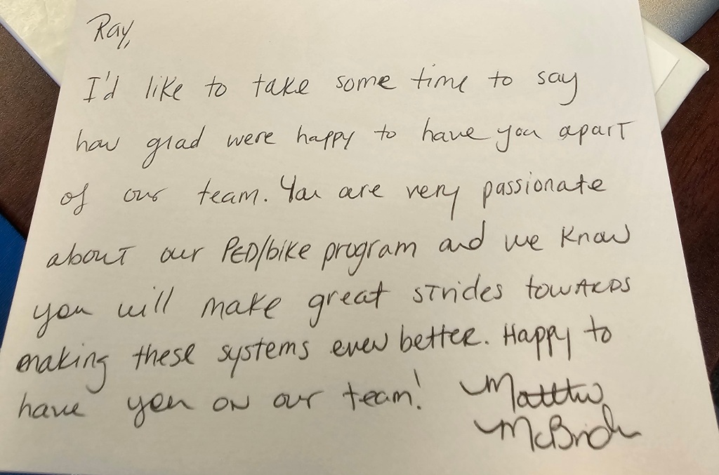
I am thankful to work with coworkers who value my passion for active transportation. I treasured receiving this handwritten letter from Matthew more than receiving an email.

Handwritten letter from Ray’s coworker

Ray’s Favorite Memphis Bike Route

I wish that I had stopped to take more photos while biking because my usual “The City at Eye Level” post is not going to be as visual as I prefer. At least I can share a map of my favorite Memphis bike route. Yes, it takes about 90 minutes. I usually stop on the way for a meal and to do errands. I enjoy the variety of bike infrastructure, which starts with speed bumps on Front St, protected bike lanes on MLK Ave, bike lanes on Peabody Ave and McLean Blvd, low-volume side streets on Jefferson Ave and Tucker St to more easily access Overton Park, wooded car-free roads in Overton Park, multi-use trails called the Hampline and Greenline, and ends with wooded trails in Shelby Farms Park.

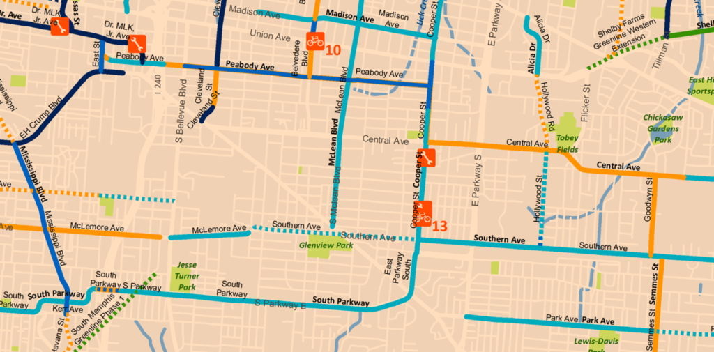
Ray’s favorite Memphis bike route. Source: Google Maps

Yes, I wish Peabody Ave connected directly to the Greenline when I am in a rush. However, I do not mind the extra distance through Overton Park too much because I enjoy forest bathing in Overton Park. As this map shows, there are plans to extend the Greenline closer to Peabody Ave. The Shelby Farms Greenline Western Extension should be connected to the South Memphis Greenline Phase 1 someday. An on-street connection will likely be needed to safely connect these future extensions to Peabody Ave. I should clarify that this is my personal opinion and not the opinion of the City of Memphis’ Bikeway and Pedestrian Program, which I manage. Do you see the South Memphis Greenline Phase 1 in the bottom left corner and how it could someday connect to the Shelby Farms Greenline?

In addition to improving the active transportation networks in Memphis, I am also looking forward to improving the City’s bike map to make it more user-friendly. For example, I want to make it easier for people to find safe routes and bike shops that will work on e-bikes. As an e-bike owner, I recommend All About Bikes. In case the bike shop is located too far, I also recommend Velotooler, which is a mobile bicycle service. I am located far from All About Bikes, so I have been trying to improve my bike repair skills. Since it is tough to change an inner tube without help, I was thankful to have a Memphis friend help me when I got a flat tire. I now carry everything on my bike that I need to change an inner tube without needing to stop at a bike shop. I still support bike shops, especially local shops, but they are not always nearby when I get a flat tire.

I also want to spotlight the importance of signals in creating safe active transportation networks. While the above map does not show bike-specific signals, I have found these signals helpful. The below bike signal is in Memphis on the Hampline at Tillman St as it crosses Sam Cooper Blvd. I would love to take this signal to the Dutch standard by adding a wacht signal (wacht is Dutch for “wait”). As I showed in this 2015 post from when I studied abroad in the Netherlands, the wacht signal allows people biking to see how long the wait time is for the signal to turn green. Since the Dutch standard is usually not legally allowed in the US, I was excited to see Portland (OR) install a wacht signal in 2015. I was actually in Portland when this signal was installed. I got to experience using it when I biked in Portland. I realize that Memphis has a unique culture and may not want to copy what Portland does. I look forward to collaborating with Memphians to create a unique approach that accomplishes the same goal of improving bike signals in Memphis.
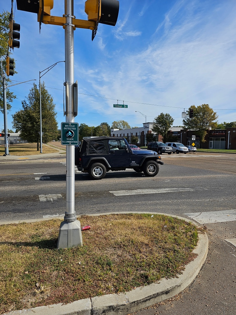
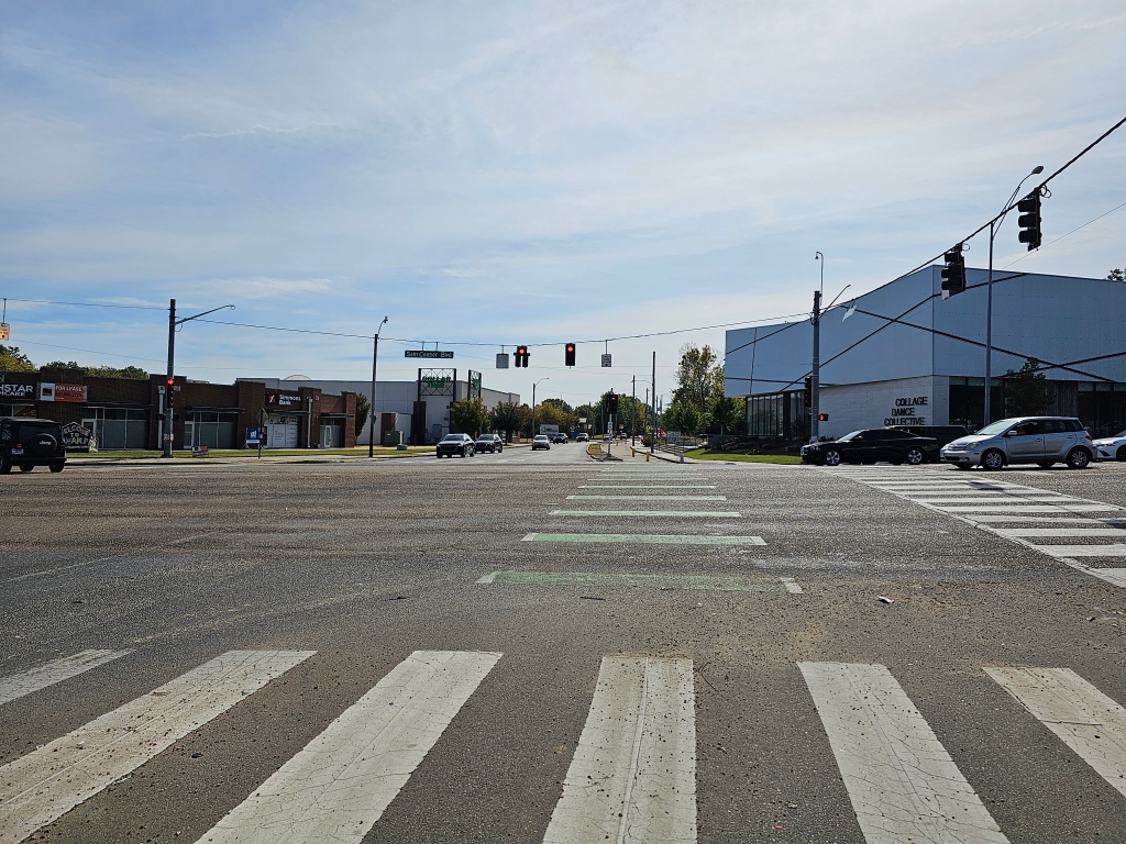
Do you see the “bicycle detected when illuminated” signal on the Hampline at Tillman St as it crosses Sam Cooper Blvd? Photo: Ray Atkinson
The “bicycle detected when illuminated” signal coordinates with the bike signal on the Hampline to cross Sam Cooper Blvd in Memphis. Photo: Ray Atkinson

My favorite artistic part of the Hampline is the upcycled tires that are found on Broad Ave, which is just north of Sam Cooper Blvd. The photo below does not show the upcycled tires well, so I need to take a zoomed in photo when I bike on Broad Ave again. The upcycled tires are produced by locals at the Binghampton Development Corporation, which has an inspiring process of hiring at-risk locals. I got to tour their process during the Binghampton Tour. I tweeted (does X still call them tweets?) from the Bike Ped Memphis account during the TAPA Conference.

Photo of upcycled tires on the Hampline during the Binghampton Tour. Photo: Ray Atkinson

Improving How Ray Navigates While Biking

Even though I majored in Geography at UNC Charlotte and love studying maps, I will admit that I sometimes struggle to navigate Memphis without looking at a map. Due to this issue, I decided to back this $700 Kickstarter for Minimis’ augmented reality (AR) glasses. Assuming the glasses are shipped on time, I should receive them by next summer. I am looking forward to publishing a blog post about my experience using the expensive glasses!

Minimis Glass Prototype video. Source: Minimis

Since I prefer to socialize when biking, I am thankful that I have been invited to participate in several slow group rides in Memphis. The below ride along the Greenline was unique because it was the first large group ride organized by City of Memphis employees. While I did not feel comfortable taking photos of kids during the Carpenter Art Garden’s kid-friendly group bike ride, I also had an amazing experience helping to lead this weekly group bike ride along the Hampline and Greenline. One of the kids actually hugged me after the ride to thank me for helping!

Hopefully, someone took a high-quality photo!
Biking the Greenline in Memphis. Photo: Ray Atkinson

Future Blog Post

I was originally planning to write about my experience volunteering on the Urban Bicycle Food Ministry’s weekly bike rides. Since I have not participated in the Wednesday evening or Saturday morning ride yet, I will need to postpone blogging about this experience.

Windsor at Eye Level

I was surprised to see that I have not published a “The City at Eye Level” post recently. The link to The City at Eye Level keeps changing, so you can longer download the free book in my previous posts. I will need to update the links. For laypeople reading my blog, I am hoping this post helps you to understand the connection between The City at Eye Level and my recent posts about the power of slowing down and its impact on creating robust in-person social networks. Does this connection make sense after reading this post?

Light Rain Cancels Bike Rental

I was planning to rent bikes from a Windsor bike shop to ride with a new friend who was raised in Windsor, which is an unincorporated town on the northern edge of the North Bay Area. This was my first time visiting Windsor. I have so many new places to explore just in Sonoma County let alone the rest of the Bay Area and California!

While my friend and I were prepared to bike in the light rain, the other renters canceled their rentals and bike tours due to the light rain. The bike shop ended up canceling all the rentals and closing for the day. I have never experienced a bike shop cancel rentals due to light rain. I guess this is a weird welcome to California!

Walk Through Windsor

My friend and I did not want the canceled bike rental to ruin our day. We decided to walk several miles through Windsor instead. Walking instead of driving allowed us to more easily see Windsor at eye level. As the below “MORE BIKES, LESS CARS” banner shows, Windsor is trying to reduce car usage and promote biking. I would include walking in with “MORE BIKES” because there is only so much space on the banner. Unfortunately, my friend and I had to walk single-file through downtown and many other parts of Windsor because the sidewalks are too narrow. Even when the sidewalk is wider, street trees and awning posts prevented us from walking side by side. I saw many people walk directly from their parked cars to their destinations. This does not encourage robust in-person outdoor social networking!

Source: Ray Atkinson

I should clarify that I do not want the street trees to be removed. As this Trees in the Curb Zone Pilot Project from the City of Portland shows, it is possible to replace on-street car parking spaces with trees. BikePortland also published this post about the City of Portland’s project. As my 2015 post from Rijswijk, Netherlands shows, I have been thinking about how to replace on-street car parking spaces with trees for several years. Since my Windsor friend said she does not want to lose car parking for her car and actually feels downtown needs more car parking, do you think rural towns like Windsor will ever have the public and political support to create a project like what Portland created?

Rembrandtkade in Rijswijk, Netherlands in August 2014. Source: Google

I wanted to share the below Spanish version of the above banner because I have never seen a banner with different languages on each side of the banner. I am still using Duolingo to improve my Spanish skills. I even bought a used Spanish textbook from the Windsor Public Library.

Source: Ray Atkinson

Another element that could improve Windsor’s eye-level walking experience and encourage the creation of robust outdoor in-person social networks is the planned SMART regional trail, which will someday connect all the way to the Larkspur Ferry Terminal that provides ferries to San Francisco. I would love to bike from Windsor to the Larkspur Ferry Terminal someday. The first signs of the planned trail and the associated Windsor SMART Station are in the below photo. The SMART Train does not currently serve Windsor, so I rode a Sonoma County bus from Santa Rosa to Windsor. I am excited to see the future of transit-oriented development (TOD) and trail-oriented development! Since trail-oriented development could also be shortened to TOD, I am curious to see what the acronym for trail-oriented development will be.

Source: Ray Atkinson

Future Blog Post

Do you understand the connection between The City at Eye Level and my recent posts about the power of slowing down and its impact on creating robust outdoor in-person social networks? If not, I will keep thinking about how to more clearly write about and show this connection in future blog posts. If so, what other topics do you want me to write about?

Does Petaluma Have Any Neighborhoods That Provide A Robust In-Person Social Network?

As I kept thinking about the distance needed to create a healthy work-life balance, I realized that being further from work may not matter if the neighborhood where I live provides a robust social network when I am not at work. Since social network in 2023 usually means an online network, I need to clarify that I am referring to an in-person social network. I have also learned through chatting with friends that my thought evaluation process for determining a robust in-person social network may not be obvious to lay people. While I plan to share research studies to try to support my evaluation process, I am trying a new approach to share my thought process. I welcome your feedback.

Donald Appleyard’s 1969 Livable Streets Research

I think the below Streetfilms video, which is in Matt Turner’s blog post, about Donald Appleyard’s 1969 Livable Streets research in San Francisco should help readers understand my evaluation process for determining a robust in-person social network. Readers can learn even more by reading Donald Appleyard’s 1981 book titled Livable Streets. His son, Bruce, published Livable Streets 2.0 in 2020. I find it depressing that livable street issues still exist in 2023. Do motorists even realize (they may need to start by even thinking about the problem) how they are impacting in-person social networks when they are driving on neighborhood streets?

A few friends have asked me what I find “depressing” in the previous paragraph. Due to how American society usually does not openly discuss mental health issues like physical health issues and people with mental health issues do not always feel comfortable discussing their issues, I am thankful to have family and friends who are comfortable enough with me to ask about my mental health issues. Regarding what I find depressing about livable street issues still existing in 2023, I am depressed that not much has been done to resolve the known issues. While these issues are known to many planners, the issues may not be known to the general public. Since the general public likely is not aware of the issues, I believe planners like myself have the tough responsibility to educate them about the issues. I believe the needle will not be moved quickly to resolve the issues until the general public is aware that these issues exist.

I am hopeful that finding a neighborhood with a robust in-person social network will also help improve my mental health issues, which includes creating a healthier work-life balance. While some people may believe that a healthy work-life balance is created by just being in a living space when not at work, I believe being home is more than just a living space. As I will discuss further during the topic on “home territory”, access to people near my living space also contributes to creating a healthy work-life balance. Since I find it challenging to stop thinking about planning issues when not at work, I am hopeful that living in a neighborhood that has a vibrant in-person social network will help me to stop thinking about planning issues when not at work. I realize my vision of the perfect neighborhood does not exist. I can at least try to find a better neighborhood to live in.

Source: Streetfilms https://vimeo.com/16399180

In case readers do not watch the video, I want readers to focus on the below figure from Donald Appleyard’s 1969 research in San Francisco because it shows how light, moderate, and heavy traffic impact in-person social networks along one block on each street. The below quotes show the quotes that meant the most to me. What quotes mean the most to you? Do you relate to any of the quotes?

I feel it’s home. There are warm people on this street. I don’t feel alone.

Resident on street with light traffic

It’s not a friendly street — no one offers to help.

Resident on street with heavy traffic
Source: Donald Appleyard’s 1969 diagram of intra-street social connections. Lines represent specific social connections and dots identify where people were reported to gather.

While I am not sure why the below figure is not black and white like the other figures, the figure was still created by Donald Appleyard. I found the figure in Jason Kottke’s blog post. According to Donald Appleyard in his 1981 book, the home territory is defined as the “area over which you feel you have a sense of personal responsibility or stewardship”. Do you see how none of the home territories drawn by residents on the heavy traffic street actually crosses the street? Now let’s compare this with the home territories drawn by residents on the light traffic street. It’s awesome to see how many home territories on the light traffic street actually cross the street!

Source: Donald Appleyard

2011 Livable Streets Research

Research conducted in 2011 on three Bristol streets found similar results. As someone who is depressed when my neighbors just go from their cars to their homes without talking with me, I can relate to the below quote. Surprisingly, I do not live on a street with heavy traffic. Due to Bristol being more walkable than Petaluma, walkability may matter more in this context than how much traffic exists on the street.

people just go from their cars to their houses

Resident on street with heavy traffic
Source: Hart, J. and Parkhurst, G. (2011) Community interaction on three Bristol streets.

The Bristol study also researched each resident’s perspective on their “home territory”. The below figure shows very similar results to what Donald Appleyard found in his San Francisco study. Do you notice how residents living on the street with light traffic drew larger home territories than the residents living on the street with heavy traffic? Do you also notice that many of the home territories drawn by residents living on the street with light traffic actually cross the street? On the other hand, do you see how only one of the home territories drawn by residents living on the street with heavy traffic actually crosses the street?

“During the interviews, residents were asked to draw their ‘home territories’. Home territory was defined as the “area over which you feel you have a sense of personal responsibility or stewardship” (Appleyard, 1981). The results confirmed Appleyard’s findings about the relationship between traffic level and the range of home territories.”

I am adding Hayden Clarkin’s tweet about this 2021 German study because it relates to the above “home territory” drawing results or mind mapping. I believe the home territories were drawn by adults, so I am more heartbroken by seeing children that are negatively impacted by cars. I know many of my readers have children. What do you think your children would draw about their trip to school? Do you drive your children to school, or do they have the freedom to walk or bike to school? If you drive them to school, did you consider providing them with the freedom to walk or bike to school?

Applying The Research To Petaluma

Before I discuss applying the research, I am aware that Petaluma is not San Francisco or Bristol. The land use context is important when applying real-world research. Due to Petaluma’s suburban land use, results from San Francisco’s urban land use may be too different to apply the research when reviewing suburban neighborhoods. One way that the land use difference could be resolved is by comparing the vehicles per day or per peak hour on each street. I plan to write more about this topic, so I could do this comparison in a future blog post.

With the above land use caveat and the understanding that my blog is not going through an academic peer-review process, I have not experienced any Petaluma neighborhoods that have a robust in-person social network. While I may not have enough time to research this further before my roommate finds someone to replace me on the lease, I am hopeful that I will find a Petaluma neighborhood with a robust in-person social network before deciding where to buy my first home within the next year or so. I try to look for silver linings, so I wanted to share the photo below that I took today in Downtown Petaluma. Despite the rain (yes, California has a wet season like Oregon), I enjoyed talking with this artist as she painted a downtown scene. This experience gave me hope that Petaluma has some in-person social networks.

Source: Ray Atkinson

In case livable street researchers read my blog, I want to challenge you to do further research using Donald Appleyard’s research by studying how in-person social networks change before and after a street has automobile traffic completely removed. This tweet helped me think of this challenge. Are you willing to accept the challenge?

I could not figure out a way to fit this 2019 Cairo research study into the above discussions of other research studies because the Cairo research did not compare automobile congestion on different streets. However, I wanted to share the Cairo results because robust in-person social networks along street blocks were studied. Even with many cars parked along the streets, I am impressed by the level of in-person social interactions. The map key shows how these interactions vary on Friday from 3-5pm and 8-10pm. What do you notice from the research results?

Behavior mapping of staying activities on the sidewalk segments of Ibrahim Street in Cairo

Future Blog Post

Since I desperately want to live in a home again that feels comfortable, I hope my next post will be about my new living situation. I wish I did not have to wait for my roommate to find someone she wants to live with before I can be removed from the lease. As I have done with previous moves, I plan to write about my commute. I may decide to stay in the same apartment complex, so I may not have a new commute. Either way, I plan to discuss further about whether my neighborhood and any other neighborhood in Petaluma has a robust in-person social network. While I am struggling to learn Spanish using Duolingo, I realize that I may need to improve my Spanish skills in order to join certain in-person social networks in Petaluma and elsewhere in California.