Getting Creative with Memphis’ Sharrows

Biking in Memphis has given me a new appreciation for the creative sharrows that I depended on for wayfinding when biking in Portland, OR. Since I have heard many bike advocates throughout the US dismiss paint as not safe enough bike infrastructure, I wanted to share how paint can actually be used to improve the safety of bike infrastructure. I have learned during my first seven months biking in Memphis that many people, especially “interested but concerned” cyclists, are unaware of safer neighborhood routes to avoid biking on dangerous highways. I believe a simple marking like a sharrow flower could provide the crucial, life-saving wayfinding that they need to find the safer neighborhood routes. As a feminist, I also believe this design could encourage more women to bike because women usually need to feel safer than men. Do you agree?

Sharrow Flower

I am trying to find an example of a sharrow flower in Memphis. Since I have not found a location so far, I am likely working on installing Memphis’ first sharrow flower. While I can’t share the location until the project is completed, I am excited to see how this project improves bike wayfinding in Memphis. I used to depend on sharrow flowers in Portland to direct me on how to stay on safer neighborhood bike routes, which are called neighborhood greenways. I want to create a similar neighborhood greenway system in Memphis. The low-hanging fruit to create this is to install sharrow flowers at intersections to connect the existing sharrows.

Source: https://clintonvillegreenways.org/2015/05/08/phase-1-route-and-design.html

Way-marking Sharrow

Another low-hanging fruit idea to create a neighborhood greenway system in Memphis is to add way-marking sharrows. These sharrows would help direct cyclists at T-intersections and other unusual wayfinding gaps in the bike network. Memphis usually puts straight sharrows on every block, so using way-marking sharrows would be a new approach.

Future Blog Post

I need to leave for an evening event. I plan to add more to this post later. Hopefully, I will be able to start writing more soon about the Safe Streets and Roads for All Safety Action Plan that I am managing.

Making a difference on the Oregon City Transportation Advisory Committee

I serve on several advisory committees throughout the Portland and Charlotte regions through my job and as a volunteer. Yes, I still serve on the Advisory Council for Sustain Charlotte’s Transportation Choices Alliance even though I no longer live in Charlotte. While most of the committee members that I serve with understand their important role and how to make a difference, some of my fellow Oregon City Transportation Advisory Committee (TAC) members have struggled with this.

In case they read my blog, I want to give them hope for how they can make a difference on our committee. Since we volunteer on the TAC and some of my fellow volunteers feel the City Commission is the only group that can make a difference, I hope this post shows them and other volunteers that it is possible to make a difference even when you have limited voting power.

Oregon City Mayor Dan Holladay appointed me to my first three-year term on the TAC in January 2019. Since I have lived in Oregon City for less than a year, I am still surprised that I was the only new candidate that was appointed to the TAC. Even though there were three open seats and four candidates, an incumbent and I were the only candidates appointed to the TAC. The remaining open seat and another open seat were filled in March 2019. I got to interview the candidates and vote on who would fill the seats. This was an awesome experience!

Even though all of the other TAC members are much older than me (some of them could be my grandpa), I am the only transportation professional and car-free member so the other members and Oregon City staff have expressed appreciation for my valuable experience. Since the older members have lived and worked through decades of Oregon City’s rich history, they have their own valuable experience to share with me. As a millennial, it feels weird to share that older people can learn from my experience when they have lived and worked much longer than me.

In addition to helping Oregon City and Clackamas County prepare for electric-assist dockless bikeshare and scootershare expanding from Portland, I am making a difference on the Oregon City TAC through the following two topics.

Canemah Family Friendly Route

While the route signs and markings have already been ordered, which means I was too late to make changes, Oregon City staff told the TAC that the Canemah Family Friendly Route is the first pilot project and they are open to making changes in the future. In order to explain my proposed change, focus on the bike symbol in the two below signs. Since I want Oregon City’s Family Friendly Route to be as successful as Portland’s Neighborhood Greenway, I feel the Family Friendly Route’s bike symbol needs to show the target audience of relaxed, family biking. The current bike symbol shows a racing or training cyclist because the cyclist is leaning over and looks stressed to beat their personal record time.

In contrast, the bike symbol on Portland’s Neighborhood Greenway shows a relaxed cyclist because the cyclist is sitting more upright. This is how I see a family biking together because they are not trying stressed to beat their personal record time. Do you see the difference between the two bike symbols?

Family Friendly Route Sign

Oregon City’s Family Friendly Route Sign

Portland Neighborhood Greenway Sign

Portland’s Neighborhood Greenway Sign

Crash Instead of Accident

While I was nervous to publicly call out Oregon City staff for saying “accident” instead of “crash” when referring to a deadly pedestrian crash involving a truck in Oregon City, staff thanked me for correcting them and explaining why they should say “crash” instead of “accident”. The staff even said they will try to use “crash” in the future. The reason why this is important is calling it an accident assumes no one, including the government for design issues, was at fault and nothing can be done to prevent the crash. Since the crash could have been prevented, it needs to be called a crash instead of an accident.

Future Blog Posts

As I stated in my previous post, my one-year work anniversary at Clackamas Community College is in June and I will have been back in Oregon for a year in June. I plan to write a post about how my one-year goals went and what my two-year goals are. Since my North Carolina-based family is planning a July 4-14 vacation with me to visit my grandmas and other relatives in Ohio and Pennsylvania, I plan to write a post about this.

Should bike map be used to show off or keep cyclists safe?

I am tired of reading news reports about cyclists dying. While I feel most people feel hopeless about how to prevent more deaths, I have been thinking about easy, cost-effective ways to help save people’s lives. As a geographer and transportation planner, I believe bike maps can help save people’s lives. However, bike maps must show the correct information. Metro, which is the MPO for the Portland region, edited its bike map after someone died while using a Portland bike map to find what the cyclist thought was a safe route. Metro’s bike map didn’t show the correct information to keep cyclists safe. However, as this cyclist asks, should a bike map be an important safety tool?

The current approach most cities in the United States are using is to build as much bike infrastructure as possible and show all of their bike infrastructure on a map. As the below figure shows, cities are using their bike infrastructure to show off to other cities and attract cyclists to move to their cities. Since there are glaring inaccuracies with the figure, which you are welcome to ask me more about, I’m not sharing the figure so you can compare cities. Instead, I’m sharing the figure so you can see how cities are competing with each other for the most miles of bike infrastructure. While it is great to see bike infrastructure, how much of the infrastructure is actually safe?

Bike infrastructure per square mile in large cities 2014

Source: 2014 Bicycling and Walking in the USA Benchmarking Report

For the rest of this blog post, I will discuss two bike maps, which I found in the Appendices of Charlottesville’s 2015 Bicycle and Pedestrian Master Plan. The first bike map shows all of Charlottesville’s bike infrastructure. The second bike map shows Level of Traffic Stress (LTS) analysis for Charlottesville’s entire road network. You can learn more about LTS analysis in this blog post. While bike infrastructure is used to create the LTS bike map, bike infrastructure isn’t the only measure used in the LTS bike map. Which bike map do you feel makes Charlottesville look like it is trying to show off to other cities and which bike map shows Charlottesville as trying to make its road network safer for people to bike?

Charlottesville Bike Map

Since many cyclists depend on maps to direct them along safe routes, bike maps need to only show bike routes that will keep cyclists safe. This blog post demonstrates my point. While Jonathan Maus doesn’t mention LTS analysis, I believe LTS analysis can be used to create a safer bike map. During my transportation planning internship at Toole Design Group, I helped create the below LTS map. Note how no bike infrastructure is included in the map legend. This is the critical difference I’m trying to make between a bike infrastructure map and a LTS bike map.

Charlottesville LTS Map

Even if a bike lane was installed on a road with LTS 4, which means it is very uncomfortable to bike on, the LTS bike map would continue to show the road as LTS 4 until the speed limit and/or annual average daily traffic (AADT) are reduced. The bike infrastructure map shows the road as having a bike lane regardless of the speed limit and AADT. This difference is why I’m a huge advocate for LTS analysis. To learn more about this difference, watch this video by Sam Schwartz Engineering and this video by Peter Furth.

The below graphic shows how LTS analysis compares with the four types of transportation cyclists. Through using a LTS bike map, “interested but concerned” cyclists can easily understand which routes they should use. A traditional bike infrastructure map forces cyclists to guess which bike lane is actually safe enough to use. What I mean by this is that a bike lane on a 45 mph road is not the same as a bike lane on a 25 mph road. Unfortunately, a bike infrastructure map doesn’t show the difference between the two bike lanes. A LTS bike map does show the difference because speed limit is included in a LTS bike map. Which bike map do you want to use when planning your next bike trip?

who does the bike facility serve

When “No Outlet”, “Dead End” and “Closed” aren’t really true: How do you sign for bicyclists and pedestrians?

The Washington, DC region is a great region to explore by bicycle. I biked about 400 miles in July and have talked with several people living in the region that also do not own a car. I met many of these people while biking on the wonderful trail systems and Beach Drive through Rock Creek Park. While we found the trail systems and know that Beach Drive is closed only to motor traffic on the weekends and holidays, the signage to reach the trail systems and the closed portions of Beach Drive do not help to inform more people about the trail systems and the closed portions of Beach Drive. Compared to most transportation projects, fixing the signage is cheap and easy. The impact of this easy fix could be tremendous in reducing congestion on area roads and helping to direct people to where they can improve their health. While I would love to take credit for coming up with the title of this post, Eli Glazier, an intern that sits next to me at Toole Design Group, posted the following to Twitter.

No Outlet Sign on Toole Design Group's Twitter

No Outlet Sign on Toole Design Group’s Twitter

Even though there is no outlet for motorists in the above photo, there is an outlet for bicyclists and pedestrians so they can reach Rock Creek Trail, which is 14 miles long. This shows how much people think about motorists and don’t consider bicyclists and pedestrians. I haven’t actually biked on Rock Creek Trail, but the following description, which I found on this site, informs me that the above signage is not the only signage issue with this trail.

“The trail also suffers from an extreme lack of directional signs. In a number of places, it is very difficult to determine the “main” trail route. Expect to take a couple of accidental side trail detours when you first ride this trail.”

I like to approach every issue I see with options for how to resolve the issue so I have researched options for how to resolve the above issue. An “Except Bikes and Pedestrians” sign can be placed below the “No Outlet” sign. The below photo, which I found here, shows an example of how this could look.

Do Not Enter Except Bikes Sign

Except Bikes Sign

The above sign could be used with the below “Dead End Except Bikes” sign to provide even more clarity.

Dead End Except Bikes Sign

Dead End Except Bikes Sign

My coworker’s Twitter post helped me to look for the signage issue in other locations. Unfortunately, I found several other locations where the signage is only for motorists and does not consider bicyclists and pedestrians. The following photo shows a “No Outlet” sign along the access road to the Sligo Creek Trail, which is 10.6 miles long. The reason why I have been including the length of the trails is because I want to inform people how long these trail networks are. They truly are long trails and a missed opportunity if someone cannot find the trail because of poor signage. As the below photo shows, the Sligo Creek Trail is near Arcola Elementary School. While I can hope the people who attend and work at this school use the Sligo Creek Trail to travel to and from school, I wouldn’t be surprised if most of them drive an automobile to and from school. If this is the case, I would start a Safe Routes to School program at this school to encourage usage of the Sligo Creek Trail to travel to and from school. I noticed several homes located along the Sligo Creek Trail so there has to be some people who can participate in the Safe Routes to School program at this school.

“No Outlet” sign along access road to Sligo Creek Trail

Since every road that ends at the Sligo Creek Trail in this area has “No Outlet” signs, I would not have known which road to proceed down to access the Sligo Creek Trail if I didn’t have a smart phone with Google Maps to direct me to the correct road. Even though most people today have smart phones, what if I didn’t have a smart phone? Would I still have been bale to find the correct road to access the Sligo Creek Trail? Without good signage, people without smart phones can easy get lost trying to find the entrance to the Sligo Creek Trail.

While the below signage isn’t as big of an issue, I don’t understand why the signage seems to assume that bicyclists and pedestrians know they are allowed to use the Sligo Creek Trail. Since I have found some trails that prohibit bicyclists, I would enjoy seeing signage informing me that I can use the Sligo Creek Trail. Signage needs to be used in both cases and not just when a certain mode of transportation cannot use the trail. The top sign clearly states that “No Motor Vehicles” are allowed on the Sligo Creek Trail. I don’t see any signage to indicate that the Sligo Creek Trail is open to bicyclists and pedestrians.

Entrance to the Sligo Creek Trail

Entrance to the Sligo Creek Trail

The following “No Outlet” signs are located on Willow Lane in Chevy Chase, MD. While there is no outlet for motorists, there is a nice path for bicyclists and pedestrians at the end of Willow Lane that connects Willow Lane to Oakridge Avenue and Leland Street.

Dead End Signs

Dead End Signs

I have used the below path several times as I bike from downtown DC to Silver Spring, MD. This path provides a nice connection between where the Capital Crescent Trail ends in Bethesda, MD and where I connect to Beach Drive in Chevy Chase, MD. Since this path is shown on Google Maps as a bike path, Google Maps directed me to use this path. What if I didn’t have a smart phone to direct me to use this path? More cyclists and pedestrians may use this path if the above “No Outlet” signs and below “Dead End” sign were corrected with “Except Bikes and Pedestrians” signs.

Dead End Sign at Entrance to Path

Dead End Sign at Entrance to Path

Several sections of Beach Drive are closed to motor vehicles within Rock Creek Park on the weekends and holidays. As the below photo shows, it appears these sections of Beach Drive are closed to all modes of transportation. This isn’t true. Since cyclists and pedestrians can use the closed sections of Beach Drive, an “Except Bikes and Pedestrians” sign should be installed to resolve this confusion. By installing this sign, more cyclists and pedestrians should use the closed sections of Beach Drive. I have been riding on the closed sections of Beach Drive every weekend and it is one of the highlights of my weekend.

Beach Drive

Beach Drive “Closed” at DC Line

The below photo shows the opening in one of the closed sections along Beach Drive so bicyclists and pedestrians can access Beach Drive when it is closed to motorists.

Opening in

Opening in “closed” section of Beach Drive

The below photo shows the white sign better so you should be able to read it. wpid-wp-1407126679805.jpeg

Have you seen “No Outlet”, “Dead End” or “Closed” signs where you live? Does the road end at the entrance to a trail or path that bicyclists or pedestrians can use? If so, do the “No Outlet”, “Dead End” or “Closed” signs include “Except Bikes and Pedestrians” signs?

Doris Day Parking in Kannapolis

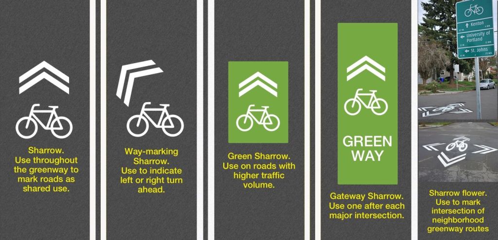
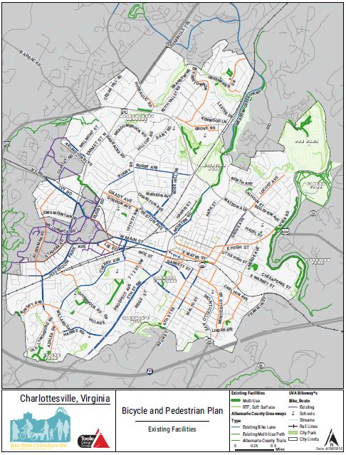
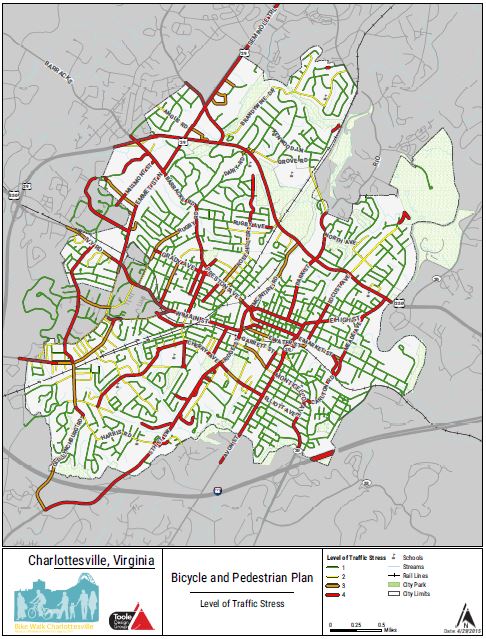
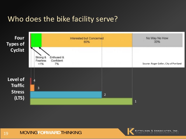
What is Doris Day Parking? Start watching this clip at 0:59 to understand what Doris Day Parking is. Almost all, if not all, buildings in Kannapolis have Doris Day automobile parking. Before I start discussing the automobile and bicycle parking situations on the North Carolina Research Campus (NCRC), I need to mention that the NCRC is not fully built out yet. However, I feel this is not an excuse for the oversupply of automobile parking on the NCRC. Since there are many Transportation Demand Management (TDM) strategies that the City of Kannapolis and NCRC can pursue instead of adding more automobile parking, I believe there is already too much automobile parking for the fully built out NCRC. While there are TDM strategies being pursued, I believe the strategies aren’t strong enough. This is evident in how there is an oversupply of automobile parking, especially Doris Day automobile parking. Doris Day automobile parking continues to be built for every single building while only a few bike racks are being built. This is only one example of how weak the TDM strategies are in Kannapolis. My goal with writing this post is to discuss the extreme contrast between the oversupply of Doris Day automobile parking and undersupply of safe and convenient bicycle parking at UNC Chapel Hill’s Building on the NCRC.

I want to fully disclose that I graduated from UNC Charlotte, which competes with UNC Chapel Hill. The reason for writing this post does not involve this competition so please remember this as you read and comment on this post. As the below photo shows, the motorist was able to park only a few feet from the entrance to the building. Since Kannapolis provides so much Doris Day automobile parking, it encourages driving an automobile for every trip.

Doris Day Parking at the UNC Chapel Hill Building on the North Carolina Research Campus

Doris Day automobile parking at the UNC Chapel Hill Building on the North Carolina Research Campus

Here is a closer view of the surface parking area. This is Doris Day Parking because the stairs to the building entrance, which can be seen on the right side of the photo, are only a few feet from the parking spaces so motorists only have to walk a few feet to enter the building. In case you are wondering, it is free to park here. Before the next photo is shown, notice the six story parking deck in the background.

Dorris Day Parking at the UNC Chapel Hill Building on the North Carolina Research Campus

Dorris Day Parking at the UNC Chapel Hill Building on the North Carolina Research Campus

Even though there are six stories, only the bottom two floors were partially used when I took the below photo around noon on a work day. Considering the fact that the NCRC isn’t fully built out yet, do you see the potential for all six floors being full someday?

I would prefer the NCRC pursue a different route. This route could reduce the likelihood of all six floors being used and prevent having the need to build another parking deck or surface lot on the NCRC. In order to achieve this route, the NCRC and City of Kannapolis would have to implement TDM strategies that encourage use of sustainable modes of transportation instead of encouraging the use of the automobile for every trip. Given the fact that Kannapolis is very dependent on the automobile, do you see the potential for Kannapolis to implement strong enough TDM strategies that would encourage enough people to shift from driving their automobile to using a sustainable mode of transportation?

6 story parking deck on the North Carolina Research Campus

6 story parking deck on the North Carolina Research Campus

Not only do motorists have a six story parking deck that is barely used, they also have wayfinding signage to direct them to the parking deck. While this wayfinding signage helps to reduce vehicle miles traveled (VMT) because motorists can more quickly find where to park, there is no wayfinding signage to help bicyclists find where to park their bike.

Wayfinding signage to direct motorist to the parking deck

Wayfinding signage to direct motorists to the parking deck

Since I was determined to find where I was supposed to park my bicycle, which I struggled to park illegally to the sign below, I walked around the entire building. I struggled to park my bicycle because I had to lift it high enough for my U-lock to fit around the sign. While holding my bicycle high enough, I also had to maneuver the U-lock through the front wheel and frame. It took me at least a minute to lock my bicycle!

Location where I parked my bicycle

Location where I parked my bicycle

To my amazement, there was actually some bicycle parking located on the right side of the building and more located on the rear of the building. However, none of the bicycle parking was Dorris Day Parking like it was for automobile parking. I find it ironic that the UNC Chapel Hill Nutrition Research Institute, which is located inside this building, is researching how to “prevent or treat diseases like obesity, diabetes and cancer.” One simple and inexpensive way to work towards this goal is to install Dorris Day bicycle parking so people can feel encouraged to bike to the building instead of drive an automobile.

Bicycle parking at the UNC Chapel Hill Building on the North Carolina Research Campus

Bicycle parking at the UNC Chapel Hill Building on the North Carolina Research Campus

To make matters worse, the bicycle parking that has been provided is the same poorly designed and installed bicycle parking that was installed at Rowan-Cabarrus Community College’s NCRC Building. Even though UNC Chapel Hill and/or the NCRC probably received Leadership in Energy and Environmental Design (LEED) points for installing wheel bender bike racks, I cannot safely use the poorly designed wheel bender bike racks. As the below photo shows, the wheel bender bike rack is poorly designed because the person who owns the bike cannot lock the bike rack with the front wheel and frame using a U-lock. Instead, the person is forced to use a wire lock, which can easily be cut.

Unfortunately, the issue goes beyond the infrastructure that is installed. Education is also needed to educate cyclists on how to properly lock their bike. This issue can be seen in how the wire lock in the below photo was only locked to the frame and not to the frame and front wheel. Since the front wheel is quick release, the front wheel can easily be stolen so a U-lock needs to be used to lock the front wheel and frame to the bike rack. The wheel bender bike racks cannot reach the frame so a safer type of bike rack is needed.

Wire lock is only locked to the frame so front wheel, which is quick release, can be stolen

Wire lock is only locked to the frame so front wheel, which is quick release, can be stolen

In addition, the wheel bender bike racks are poorly installed because the side entrance door to the building is locked so visitors have to walk around to the front of the building to enter. The poorly designed and installed bicycle parking does not promote bicycle use to the building. Since there isn’t correctly designed and installed bicycle parking, I am forced to risk getting a ticket for parking my bicycle illegally. I value the safety of my bike more than using an inferior product. Will UNC Chapel Hill or the NCRC install safe bike racks to replace the wheel bender bike racks?

Inconveniently located and poorly designed bicycle parking

Inconveniently located and poorly designed bicycle parking

The below photo shows one potential location for inverted U bike racks to be installed. I chose this location because it provides cyclists with convenient access to the front door, which is open for visitors. Through providing people with convenient bike parking, it encourages them to bike to the building instead of drive an automobile.

Location for Inverted U bike racks

Location for Inverted U Bike Racks (Photoshop: Keihly Moore/Lawrence Group)

One way to encourage people to bike to the building even more is to provide covered bike racks so bikes aren’t exposed to the elements.

Location for Covered Inverted U Bike Racks (Photoshop: Keihly Moore/Lawrence Group)

Location for Covered Inverted U Bike Racks (Photoshop: Keihly Moore/Lawrence Group)

I have discussed the extreme contrast between the oversupply of Doris Day automobile parking and undersupply of safe and convenient bicycle parking. Since I move to Silver Spring, MD on June 29, I only have time to write two more blog posts before I leave. My next post should be about my proposed redesign of a difficult bicycle connection between where the proposed buffered bike lanes on Loop Road end and the proposed bike lanes on Mooresville Road end. Following this post, I plan to discuss my expectations of living car-free in Silver Spring, MD and the Washington, DC region. After I arrive in Silver Spring, MD, I plan to discuss whether or not my expectations came true and what challenges and benefits I am experiencing from living car-free in Silver Spring, MD and the Washington, DC region.